Tornado Watch for Kenosha as Severe Storms Batter Southeast Wisconsin
A Tornado Watch remains in effect for Kenosha, Racine, and Walworth Counties until 9 p.m. Thursday, June 12, 2026, as a powerful line of severe thunderstorms moves across southeast Wisconsin. The National Weather Service has issued the watch, warning residents to remain alert for rapidly changing conditions, including the potential for tornadoes, damaging winds, and large hail.
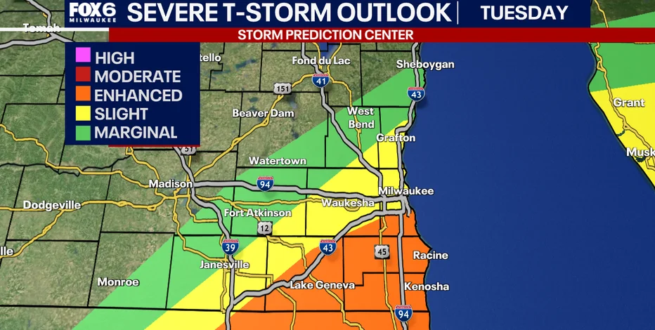
According to the Storm Prediction Center, the entire region is under an Enhanced (Level 3) risk for severe weather, with the greatest threats concentrated in the southern counties near the Illinois border. Meteorologists at TMJ4 and FOX6 report that storms are sweeping through the area between 4 p.m. and 8 p.m., moving from west to east. The Milwaukee metro area is expected to experience its worst weather between 5 p.m. and 7 p.m., while Kenosha, Racine, and Walworth face the highest tornado risk through the evening.
In addition to the Tornado Watch, a Severe Thunderstorm Warning was in effect for Sheboygan County until 7:15 p.m., and flood advisories stretch across multiple counties, including Walworth, Ozaukee, Jefferson, and Milwaukee. The National Weather Service has issued a Flood Watch for all of southeast Wisconsin until 11 p.m., as heavy rain could lead to localized flooding in low-lying and urban areas.
Key Details for Kenosha Residents
- Tornado Watch: Until 9 p.m. for Kenosha, Racine, and Walworth Counties.
- Primary Threats: Tornadoes, damaging winds up to 75 mph, large hail, and heavy rain.
- Timing: Storms moving through between 4 p.m. and 8 p.m., with the worst weather in southern counties from late afternoon into early evening.
- After the Storms: Conditions improve overnight, with partly cloudy skies and lows around 62 degrees. Friday brings mostly sunny skies and a high near 83.
Authorities urge residents to stay tuned to local weather alerts, have multiple ways to receive warnings, and seek shelter immediately if a Tornado Warning is issued. The National Weather Service recommends going to a basement or an interior room on the lowest floor of a sturdy building.
Why This Storm System Matters: Enhanced Risk and Unseasonable Warmth
This severe weather outbreak is part of a broader pattern affecting the upper Midwest and Great Lakes region, driven by unseasonably high temperatures. On Wednesday and Thursday, temperatures in the Chicago area and southern Wisconsin climbed into the low 90s, with heat indices approaching 100 degrees. This created an unstable atmosphere ripe for strong thunderstorms.
According to NBC Chicago, multiple waves of storms have moved through the region since Wednesday afternoon. The first round brought damaging winds and the possibility of brief tornadoes, with gusts strong enough to down trees and potentially cause structural damage. NBC 5 Storm Team Meteorologist Alicia Roman warned that winds of up to 75 mph "could definitely do some damage to some structures."
The second round, hitting Thursday afternoon and evening, poses the greatest risk for tornadoes in Kenosha and surrounding counties. The Storm Prediction Center's Enhanced (Level 3) risk level indicates that numerous severe storms are likely, some of which could be long-lived and intense. This is a step above the typical Slight (Level 2) risk and means that residents should be prepared for significant weather impacts.
Stakes for the Community
For Kenosha County, which has a population of over 170,000 and includes the cities of Kenosha, Pleasant Prairie, and Bristol, the threat is especially concerning. The area is home to major highways like I-94 and I-41, as well as industrial parks and residential neighborhoods. A tornado or severe straight-line winds could disrupt transportation, damage homes and businesses, and pose risks to public safety.
Flooding is also a major concern. The Flood Watch covers Kenosha, Racine, Milwaukee, and several other counties, with rainfall rates expected to exceed 1 to 2 inches per hour in some storms. Urban areas with poor drainage and low-lying roads could see water rise quickly, making travel hazardous.
Broader Weather Pattern and What Comes Next
The severe weather hitting Kenosha is part of a larger system affecting much of the Midwest. On Wednesday, storms rolled through northern Illinois and southern Wisconsin, with a severe thunderstorm watch issued for counties including DeKalb and McHenry in Illinois and Kenosha in Wisconsin. The Chicago area also remains under a severe thunderstorm watch until 10 p.m. Thursday, with the potential for additional waves of storms overnight.
Meteorologists note that this pattern is fueled by a strong low-pressure system drawing warm, moist air from the Gulf of Mexico into the region. The clash with cooler air from the northwest creates the instability needed for supercell thunderstorms, which can produce tornadoes.
Outlook for the Weekend
Fortunately, the severe weather is expected to subside after Thursday evening. Friday will be mostly sunny, windy, and less humid, with highs near 80 degrees in Milwaukee and the upper 70s in Kenosha. The weekend looks promising overall, though there is a chance for more showers and thunderstorms Saturday evening. Sunday will be cooler and breezy, with highs in the low 70s, and Monday will bring partly sunny skies and highs around 74.
According to FOX6 Chief Meteorologist Tom Wachs, the weekend storm chances are not expected to be as severe as Thursday's event, but residents should remain aware of changing conditions.
Perspective: The Frequency of Severe Weather in the Region
While this storm system is significant, it is not unprecedented for southern Wisconsin. The region sits in a transitional zone between the Great Lakes and the central Plains, where contrasting air masses frequently collide. Spring and early summer are the peak seasons for severe weather, with June often seeing an uptick in tornado activity.
According to the National Oceanic and Atmospheric Administration (NOAA), Wisconsin averages about 23 tornadoes per year, most of which are rated EF0 or EF1. However, stronger tornadoes occur periodically. The 2024 severe weather season, for example, saw several tornado outbreaks across the Midwest, including an EF2 tornado that struck near Madison.
In a related incident, earlier this year, Denver Sirens Sound by Mistake as Tornado Warnings Sweep Colorado Plains, highlighting the importance of accurate siren systems and public vigilance. While sirens are a key tool for warning residents, they are just one part of a comprehensive safety plan.
What This Changes for Residents
This storm serves as a reminder of the importance of preparedness. residents are encouraged to review their emergency plans, ensure they have a battery-powered weather radio, and know the difference between a Tornado Watch (conditions are favorable) and a Tornado Warning (a tornado has been spotted or indicated by radar).
Local officials also stress that with the threat of heavy rain and flooding, drivers should never attempt to cross flooded roadways. Turn around, don't drown.
How to Stay Safe and Informed
As the storm system continues to move through southeast Wisconsin, staying informed is critical. The following resources are available for real-time updates:
- Local TV Stations: TMJ4, FOX6, and NBC Chicago provide continuous coverage and live radar.
- Weather Apps: The FOX6 Storm Center app and the FOX Weather app offer alerts and interactive radar.
- NOAA Weather Radio: This is a reliable source for watches and warnings, even during power outages.
- Social Media: Follow meteorologists on Facebook and Twitter for updates.
For those in Kenosha County, the Tornado Watch remains in effect until 9 p.m. After the storms pass, a quieter pattern settles in for Friday, with mostly sunny skies and highs in the low 80s. The weekend will bring a slight chance for storms Saturday evening, but overall conditions will be much calmer.
Other News: A Busy Week for Headlines
While the weather dominates local news, other stories are making national and international headlines. In sports, Raul Jimenez Opens World Cup 2026 with Miracle Recovery and Scoring Record in Sight captivated soccer fans around the globe. Meanwhile, Gary Neville Warns Thomas Tuchel’s England Squad Has Fatal World Cup Flaw sparked debate among football analysts.
In entertainment, Bad Bunny Meets Pope Leo in Madrid: A Meeting of Two Worlds, No Photos Released drew international attention, while Bradley Cooper and Gigi Hadid Step Out for Rare Dinner Date with Will Arnett in Santa Monica made headlines in celebrity news.
However, for residents of Kenosha and southeast Wisconsin, the immediate concern remains the weather. With the Tornado Watch ending at 9 p.m. and calmer conditions expected Friday, the priority is safety through the evening hours.
Stay Prepared
- Keep devices charged and notifications on.
- Have a flashlight, first aid kit, and emergency supplies ready.
- Identify a safe room in your home, such as a basement or interior closet.
- Stay away from windows during severe storms.
Conclusion
A Tornado Watch for Kenosha, Racine, and Walworth Counties remains in effect until 9 p.m. Thursday as severe storms sweep through southeast Wisconsin. The enhanced risk for tornadoes, damaging winds, and heavy rain means residents must remain vigilant. After the storms pass, drier and cooler weather arrives Friday, offering a welcome break from the volatile conditions.
For the latest updates, continue to monitor local news and official weather sources. Safety first, and stay weather-aware.
Comments