
Severe Thunderstorm Watches Sweep US: New Jersey, Utah Face High Winds
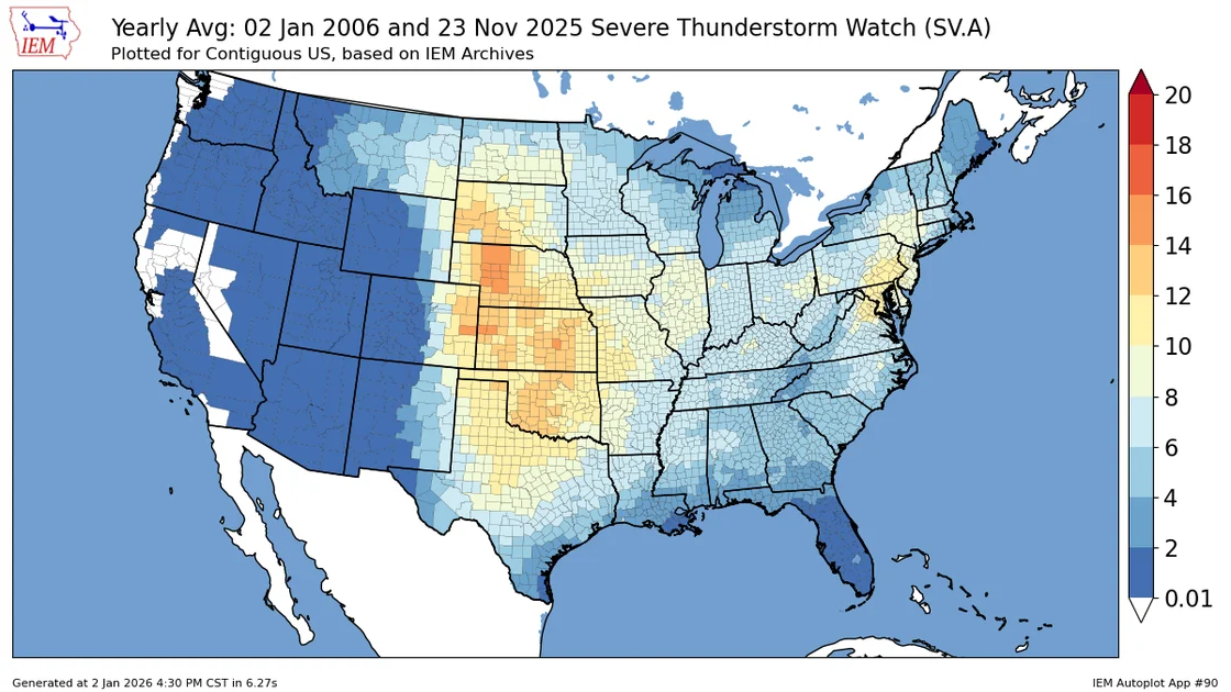
A wave of severe thunderstorms is battering multiple regions of the United States, prompting the National Weather Service (NWS) to issue widespread severe thunderstorm watches. On Thursday, August 27, the entire state of New Jersey was placed under a watch, while areas of northern Utah remain under threat from a separate weather system that has already caused damage over the weekend. These watches signal that atmospheric conditions are ripe for the development of powerful storms capable of producing damaging winds, large hail, and torrential rain.
The most recent and expansive advisory covers all 21 counties in New Jersey. Issued at approximately 12:45 p.m. Thursday, the watch extends through 8 p.m. and also includes the New York City and Philadelphia metropolitan areas. Forecasters are warning of storms that could deliver between 3 and 5 inches of rain, wind gusts strong enough to down trees and power lines, and the potential for an isolated tornado. This event is part of what has been described as a stormy summer for the Garden State, which has already confirmed five tornadoes this year. A separate flood watch is also active across most of New Jersey through early Friday morning due to the risk of flash flooding on roadways and in poor-drainage areas.
Utah: A Weekend of Severe Weather Leaves its Mark
Meanwhile, in the Mountain West, the NWS's Storm Prediction Center issued a severe thunderstorm watch for much of northern Utah on Sunday afternoon. This watch, which remained in effect until 10 p.m., covered a wide arc of counties including Box Elder, Cache, Davis, Morgan, Rich, Salt Lake, Summit, Tooele, Utah, Wasatch, and Weber. The region saw dramatic conditions over the weekend, with lightning lighting up the sky and storms downing power lines in Ogden. The primary threats from this system were wind gusts up to 70 mph and frequent lightning. The watch was a preemptive alert that conditions were favorable for severe storms, urging residents to stay vigilant and be prepared to take shelter if a more urgent warning was issued.
The dual watches highlight a volatile late-August weather pattern across the country. In both cases, the watch is a step below a warning. A severe thunderstorm watch means that conditions are right for severe weather to form. It is a call for preparedness, not panic. In contrast, a warning means that severe weather has been spotted or is imminent on radar, and immediate action is required for safety. For residents in New Jersey, the repeated storms have raised concerns about property damage and power outages, especially after a summer that has already seen its share of damaging weather events.
Louisiana: Targeted Watches and Localized Risks
Further south, a more localized severe thunderstorm watch was issued for parts of southeast Louisiana on Monday. The NWS placed Livingston, St. Helena, and Tangipahoa Parishes under a watch until 7 p.m. that day. The primary threats there were isolated wind gusts up to 65 mph and the possibility of quarter-size hail. While this particular watch has since expired, it illustrates the frequent and localized nature of severe weather threats during this time of year. The storms in Louisiana were part of a front moving south, bringing scattered showers and thunderstorms to the I-10/12 corridor. Although this specific threat has ended, it underscores that severe weather watches can be issued, lifted, and re-issued as conditions change.
Understanding the Threat: Watches, Warnings, and Preparedness
The series of watches is a reminder of the importance of understanding weather terminology. A watch, by definition, is less urgent than a warning but serves a critical purpose: it puts the public on notice to be aware of the potential for stormy weather. It is the time to review safety plans, secure outdoor furniture, and ensure that mobile devices are charged and weather apps are active. With more than 60 million Americans currently under some form of severe weather alert, emergency management officials stress the value of these alerts in saving lives and property. The recent storms serve as a high-stakes reminder that late summer can be just as dangerous as the peak of spring storm season. As climate patterns continue to shift, meteorologists note an increase in the frequency and intensity of such events, making it more important than ever for communities to stay informed and heed official warnings. For those following the pattern, Dust Storm Warning Hits Phoenix Area as Severe Storms Sweep Arizona shows a related hazard, while Liverpool Weather: Thunderstorm Warning Extended as Heavy Rain and Hail Loom indicates that this is a global weather phenomenon.
Comments