
France and Spain Grapple with a 'Monster' as Wildfires Create Their Own Weather
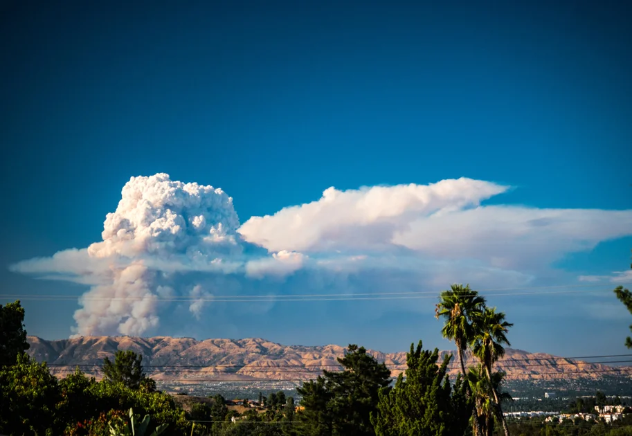
Firefighters in southwestern France and central Spain are battling a new, terrifying type of wildfire that generates its own violent weather, including lightning and shifting winds. For the first time in French history, a pyrocumulonimbus -- a massive 'fire cloud' -- was observed on Friday and Saturday in the Gironde region near Bordeaux, turning the inferno into an unpredictable, self-sustaining storm.
The fires, among the worst either country has seen in peacetime, have already forced more than 325,000 people to flee their homes. In France, the flames have consumed over 32,000 hectares of forest, while a single fire in Spain’s Avila province is now the largest ever recorded in the country, with a perimeter of 280 kilometers encompassing 77,000 hectares.
“It’s a David-versus-Goliath scenario,” said Lieutenant Colonel Eric Brocardi, spokesman for the National Firefighters Federation of France (FNSPF), describing the challenge of confronting a fire that creates its own winds. “The fire front is constantly shifting. We cannot fight it directly.”
What Is a Pyrocumulonimbus? The ‘Fire-Breathing Dragon of Clouds’
A pyrocumulonimbus, also known as a cumulonimbus flammagenitus or simply a fire storm, is an extreme weather phenomenon usually seen only in wildfire-prone regions like Australia and North America, or during volcanic eruptions. Until now, it had never been documented in France.
The cloud forms when the intense heat from a massive wildfire roasts the air near the ground, causing it to rise rapidly in a towering column. As this superheated air reaches cooler altitudes, moisture condenses, forming a turbulent, smoke-laden cloud.
“The rise in ground temperature at the heart of the blaze is so extreme that the intense heat surges upward in a column, meeting cooler air masses at the top,” Brocardi explained. This contact creates a pyrocumulonimbus -- but in this case, “one devoid of moisture,” he noted.
According to NASA, which calls the phenomenon the “fire-breathing dragon of clouds,” these fire clouds can generate violent downdrafts, fire tornadoes, and most dangerously, lightning. The electrical activity inside the cloud can strike embers on the ground, sparking entirely new fires miles away from the main blaze.
“This smoke cloud generates its own weather system, causing anything in its path to spontaneously combust. Lightning forms within the cloud, striking the embers on the ground and further fuelling the fire,” Brocardi said. “It produces a low, rumbling sound.”
Mark Vermeulen, the director of the Gironde fire service, described the moment the pyrocumulonimbus erupted. “When this phenomenon breaks out, it’s like confronting a hurricane,” he said. “You don’t stop a hurricane -- you protect human life, you protect installations, and when it calms down, you attack to try to fix the fire.”
The Fire Turns 'Convective': Unpredictable Winds and Multiple Fronts
The pyrocumulonimbus makes a wildfire “convective,” meaning it creates its own winds that constantly shift direction, unlike a standard fire that spreads in a predictable conical pattern. This makes the blaze nearly impossible to model or contain.
“The result is that it spreads in every direction and develops multiple fire fronts, making the situation completely unpredictable,” Brocardi told AFP.
In practical terms, this means conventional firefighting tactics are useless. “We don’t know how the blaze will spread; the fire front is constantly shifting,” he added. Firefighters have reached a point of “operational impossibility,” forcing them to adopt a defensive, war-like strategy of retreat and containment rather than direct attack.
In Spain, the situation is equally dire. “We are dealing with a monster,” said civil protection chief Virginia Barcones. Spanish Prime Minister Pedro Sánchez warned that “difficult hours lie ahead” as a new fire near Valencia forced another 15,000 to evacuate over the weekend. A New Zealand tourist arriving in Madrid reported seeing the fire “very close to the airport,” while a Canadian tourist said the smoke smell irritated her throat.
Broader Implications: Climate Change and a Future of Fire Storms
The emergence of pyrocumulonimbus clouds in Europe is a stark warning that extreme fire behavior, once confined to regions like California and Australia, is expanding its reach as the planet warms.
Scientists say climate change is making heatwaves more intense and droughts more prolonged, turning forests into tinderboxes. The current fires in France and Spain have been fueled by successive heatwaves and a lack of rain since May, which has parched woodlands to near-explosive conditions.
“Salvation will come either from the sky -- in the form of rain, though it would need to pour heavily for three days -- or by finding a way to steer the fire toward a place where it will die out on its own, like the sea,” Brocardi said.
French President Emmanuel Macron has called a crisis cabinet meeting for Monday morning, while other European Union countries have already sent aircraft, crews, and vehicles to assist. In the Gironde region, authorities are also keeping a close watch on sensitive industrial sites near the flames, including powder factories and missile plants.
As emergency services face this new reality, the battle is no longer just against flames, but against the sky itself. In an era of warming climates and intensifying wildfires, the “fire-breathing dragon” is no longer a distant phenomenon -- it has arrived in Europe.
For more on how extreme weather events are impacting global stability, see our coverage of Hurricane Genevieve Becomes Season’s First Major Category 4 Storm in Pacific.
Comments