
Farmers' Almanac First Snowfall Map: When Will Snow Reach You?
The Farmers' Almanac has released its updated first snowfall map, giving Americans a region-by-region guide to when the season's first measurable snow typically arrives. The map, updated on September 9, 2026, divides the Lower 48 into five zones, ranging from August–September in the highest northern Rockies to December or later across the Deep South and Gulf Coast.
According to the Almanac, the highest elevations of the northern Rockies can see their first flakes as early as August or September. Much of the northern Rockies, northern Plains, and Upper Midwest typically sees its first measurable snow in October or early November. November is common across the Great Lakes, central Rockies, interior Northeast, and higher Appalachians. The central Plains, Ohio Valley, and Mid-Atlantic interior often wait until late November or December, while the Deep South, Gulf Coast, and desert Southwest lowlands may not see snow at all in a given winter.
The guide emphasizes that this is a climatological tool, not a storm-specific forecast. Elevation, latitude, nearby bodies of water, and the prevailing weather pattern can shift the first snow earlier or later. Denver's average first measurable snowfall is around October 18, but the city has seen it as early as September and as late as December.
A Guide, Not a Guarantee
The Almanac distinguishes between three milestones: first flakes, first measurable snow, and first accumulating snow. The map focuses on measurable snow—typically at least 0.1 inches—which is what most people mean when they ask, "When will it snow where I live?" The variability is stark: while mountain peaks may receive snow in September, lower elevations in the same state might not see flakes until November.
Why It Matters: Skiers, Planners, and a Potential Super El Niño
For skiers and snowboarders, the map offers a rough timeline for when natural snow might begin building the base at higher elevations. Resorts in the northern Rockies and Upper Midwest often see meaningful snowfall in October, while those in the Northeast and mid-Atlantic typically wait until November or December. However, the Almanac cautions that early snow often melts before winter settles in, and ski areas depend on sustained cold temperatures and snowmaking as much as natural snowfall.
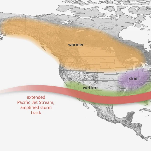
But this year's first snowfall patterns could be disrupted by a developing El Niño in the Pacific. NOAA's Climate Prediction Center estimates a greater than 90% chance that the event could become "very strong," with a 69% chance of a historic event exceeding previous El Niño strengths dating back to 1950. The Farmers' Almanac warns that El Niño provides a broad probabilistic signal, not a guarantee, but notes that the southern tier pattern is highly reliable in strong El Niño years.
Sharp Contrasts Ahead
The Farmers' Almanac's 2026–2027 winter outlook predicts "sharp contrasts across the country," with some regions facing repeated storms and heavy, wet snow while others experience milder stretches interrupted by quick cold snaps. The Almanac forecasts an active storm track from Southern California through Texas and the Gulf into the Southeast, bringing heavier-than-normal precipitation. A second storm path may guide systems along the Eastern Seaboard, increasing the chance of rain, wintry mixes, and snow from the mid-Atlantic into New England.
"Keep the snow shovel, rain boots, and ice scraper close at hand," the publication advises. "This winter, you may need all three."
Perspective: A Warming Climate and the El Niño Wild Card
The first snowfall map arrives as Americans grapple with increasingly variable winters. While the Almanac's guide is based on long-term climatology, individual years can deviate dramatically. The potential Super El Niño adds another layer of uncertainty. Historically, strong El Niño winters tend to bring cooler, wetter conditions to the southern U.S. and milder weather to the northern tier, but the exact placement of the jet stream can make or break snow forecasts in transition zones like the mid-Atlantic.
For now, the map serves as a reminder that winter is coming—even if its arrival time remains stubbornly unpredictable. Whether you're a skier hoping for early powder or a homeowner dreading the first shovel, the Almanac's guidance offers a starting point, not a final answer. As the publication itself notes, the map is "a climatological guide rather than a forecast for one particular storm."
Comments