
Dust Advisories Create Dual Threats Across Florida and Arizona
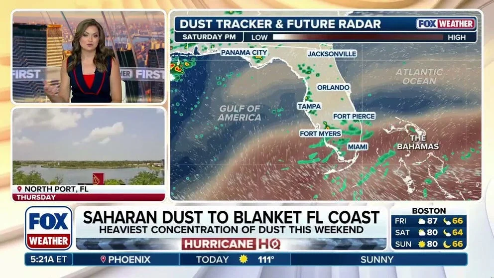
Dust advisories are in effect across two major U.S. regions this weekend, with Florida battling a Saharan dust plume that is intensifying dangerous heat and Arizona facing blowing dust from thunderstorms that is cutting visibility and creating hazardous travel conditions. The overlapping weather events are forcing millions of residents to adjust their plans as July heat and storm activity peak.
In Florida, a heat advisory remains active for more than 50 counties across the peninsula, with heat index values reaching as high as 111°F through the weekend. The culprit is a high-pressure system combined with a thick layer of Saharan dust that has settled over the state, suppressing the afternoon thunderstorms that typically provide relief from summer heat. The dust is also creating hazy skies and contributing to record-breaking temperatures.
In Arizona, a Blowing Dust Advisory was in effect until 11 p.m. Saturday for most of the viewing area outside higher elevations, as severe thunderstorms generated wind gusts that could exceed 70 mph. Dust Storm Warnings were likely as stronger storms pushed through the region, with Pima, Pinal, Graham, Greenlee, Cochise and Santa Cruz Counties under a Severe Thunderstorm Watch through 10 p.m.
Saharan Dust Arrives in Florida
A fresh plume of Saharan dust moved across the Atlantic and into Florida earlier this week, arriving just as a strong high-pressure system settled over the state. The combination has driven actual air temperatures into the mid- and upper 90s, with heat index values — which factor in humidity — spiking between 108°F and 112°F across East Central Florida.
According to the National Weather Service, the dust layer acts as a lid on the atmosphere, suppressing thunderstorm development that would otherwise bring cooling rain. Rain chances have fallen to just 20% to 30% in many areas during a time of year when daily storms are the norm.
Meteorologists warn that the heat will intensify early next week, with South Florida potentially approaching record highs. In Miami, the record high of 95°F set in 1976 is threatened by a forecast high of 94°F. Overnight lows are also expected to remain exceptionally warm, with many locations across South Florida possibly not falling below 82°F. The Florida Keys could come close to tying the record warm low of 86°F set in 2023.
Arizona Dual Threats: Dust and Flash Flooding
Arizona’s weather profile is more complex, with the region facing both dust and flash flooding risks simultaneously. The Blowing Dust Advisory, which covers most of Southern Arizona outside higher elevations, is tied to thunderstorms that are expected to kick up dust and cut visibility to near-zero in some areas.
An Air Quality Alert is also in effect in Pinal County because dust in the air is creating high pollution levels. That alert exists alongside a broader storm threat that includes flash flooding possible across most of Southern Arizona. The dual hazards mean residents and travelers must navigate dry, dusty roads that can suddenly become slick with heavy rain.
Rainfall rates in Cochise and Santa Cruz Counties could reach around 1 to 2 inches per hour, raising the chance that fast-moving storms will create dangerous roads and sudden runoff. The combination of dust and rain is particularly dangerous for drivers, as dust can reduce visibility to near-zero before rain begins, and then wet roads can become slippery once precipitation starts.
Why These Dust Events Differ
While both Florida and Arizona are under dust advisories this weekend, the mechanisms behind the dust differ significantly, and the risks are distinct.
Saharan Dust: A Natural Climate Driver
The Saharan dust arriving in Florida is a natural phenomenon that occurs several times each year, when strong winds over the Sahara Desert lift vast amounts of mineral dust into the atmosphere. This dust can travel thousands of miles across the Atlantic Ocean, often reaching the Caribbean, Florida, and even parts of South America.
This particular plume arrived at a time when a high-pressure system was already building over the southeastern United States. The sinking air associated with the high-pressure system compresses and warms, adding to the heat caused by the dust layer limiting cloud formation. The result is a perfect storm for heat: abundant sunshine, no afternoon storms, and air that is already hot before the dust layer traps additional warmth near the surface.
The dust itself can also pose health risks, particularly for people with respiratory conditions such as asthma or COPD. Fine particulate matter in the dust can irritate the lungs and trigger breathing difficulties. Health officials are advising residents to limit outdoor activity during the hottest parts of the day and to monitor air quality indices.
Southwest Blowing Dust: A Summer Storm Feature
In Arizona, the blowing dust is a more localized and immediate hazard. Severe thunderstorms are generating strong outflow winds that pick up loose soil from the desert, creating walls of dust that can reduce visibility to near-zero in seconds. These sudden dust storms, sometimes called haboobs, are notorious for causing multi-vehicle pileups on major highways.
The Blowing Dust Advisory in Arizona is time-limited, expiring at 11 p.m., but the storm threat persists through the weekend. Storm chances remain elevated at 60% through Sunday, with a forecast high near 102°F. Monday carries a 70% chance of thunderstorms with a high near 99°F.
Unlike the Saharan dust, which is a long-duration event that affects a broad area, Arizona's dust advisories are shorter-lived and more closely tied to individual thunderstorm cells. However, the risk of sudden, severe visibility loss makes them potentially more dangerous for travelers.
Broader Implications and Trends
The dual dust advisories highlight a larger pattern of extreme weather events affecting different regions of the United States simultaneously, each demanding different preparation and response strategies.
Climate Change and Dust Frequency
Scientists have noted an increase in the frequency and intensity of both Saharan dust outbreaks and localized dust storms in the Southwest, trends that are consistent with climate change projections. Warmer global temperatures are amplifying drought conditions in the Sahara, making more dust available for wind transport. Similarly, prolonged drought in the Southwest has reduced vegetation cover, leaving more soil exposed to wind erosion when thunderstorms generate strong outflow winds.
In Florida, the Saharan dust plume is arriving at a time when summer heat is already breaking records across the state. The combination of dust and extreme heat could become more common as climate change continues to shift weather patterns.
Travel and Infrastructure Impacts
Both dust events are forcing adjustments to travel plans and daily routines. In Florida, outdoor events have been rescheduled or moved indoors, and cooling centers have been opened in several counties to help residents cope with the heat. The hazy skies from the dust are also affecting air quality and visibility, though not to the extent seen in Arizona.
In Arizona, travelers are being urged to avoid driving during dust storms and to pull over safely if visibility deteriorates. The Arizona Department of Transportation has issued warnings for major highways, including Interstates 10 and 19, where blowing dust is most likely.
The health implications for vulnerable populations are significant. In both states, children, the elderly, and people with pre-existing respiratory conditions are at elevated risk. Health officials recommend staying indoors with windows closed, using air purifiers if available, and avoiding strenuous outdoor activity during peak heat hours.
What the Coming Days Hold
The Saharan dust is expected to linger over Florida through the weekend, with a gradual return of typical summer storms early next week. Rain chances are forecast to recover to 40% to 50% by Sunday and Monday. However, the heat is expected to intensify before any significant relief arrives.
In Arizona, storm chances will persist through the week, with gradually decreasing temperatures. Highs are expected to drop into the 90s by the middle of the week, offering some relief from the near-100°F temperatures seen over the weekend. However, dust advisories could be reissued if new thunderstorm development generates strong winds.
The contrast between the two regions — Florida's long-duration heat driven by Saharan dust and Arizona's short-term, storm-linked dust hazards — underscores the complexity of weather forecasting in a changing climate. Residents in both states should monitor local advisories, stay hydrated, and avoid unnecessary travel during hazardous conditions.
For readers following other major events this weekend, the World Cup Quarterfinals Today: Norway vs England and Argentina vs Switzerland Headline Saturday Slate offers a shift in focus, while the Cyclospora Outbreak: Over 3,000 Cases of Explosive Diarrhea Reported Across US highlights a different kind of health concern making headlines this month.
Comments