Tornado Warning and Watch: Severe Storms Roar Across Tallahassee Region
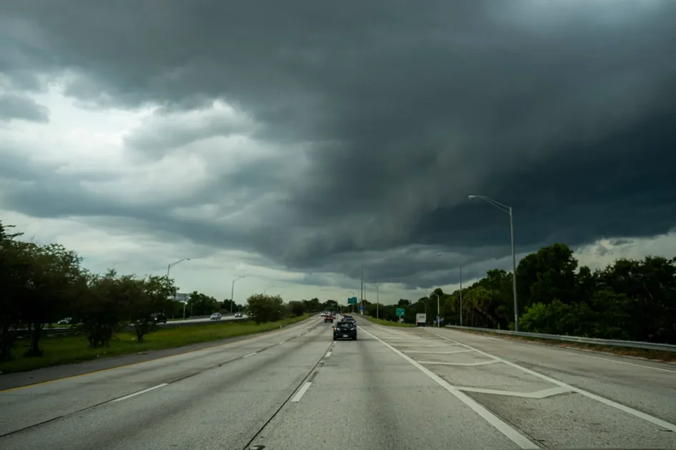
A tornado warning was issued for parts of the central Florida Panhandle early Thursday, May 7, 2026, as a powerful line of severe thunderstorms swept eastward, bringing threats of damaging winds, large hail, and isolated tornadoes to the Tallahassee area and beyond. The warning, issued by the National Weather Service (NWS), covered portions of Bay, Calhoun, Holmes, Jackson, Walton, and Washington counties, including cities such as Vernon, Alford, and Caryville. Radar indicated a tornado, with quarter-sized hail possible, and the warning remained in effect until 11:15 a.m. CT.
The activation follows a broader tornado watch that was issued early Thursday morning for 16 counties across the Florida Panhandle and western Big Bend region, including Leon County, where Tallahassee is located. The watch, initially set to expire at 2 p.m. ET, was later adjusted and extended for some areas. According to local meteorologists at WCTV, the watch was prompted by favorable atmospheric conditions over much of South Georgia and North Florida, where the potential for severe storms to produce brief tornadoes was elevated. As of 10 a.m. on May 7, the storm line stretched from northern Clinch County in Georgia back through the Florida-Alabama line, tracking eastward at a steady pace.
What Residents Should Know
Residents in the warned areas were urged to take immediate action. A tornado warning means a tornado has been spotted or indicated by radar, and people should move to an interior room on the lowest floor of a sturdy building, avoiding windows. The NWS warned that there is imminent danger to life and property. The same storm system also triggered severe thunderstorm warnings for parts of the region, with wind gusts up to 70 mph and golf-ball-sized hail possible as the line moved from Chipley to Vernon at 50 mph.
Why This Matters: The Stakes for Tallahassee and Surrounding Communities
The severe weather outbreak on May 7 puts a large population at risk, including residents of Tallahassee, the state capital, and smaller communities in the Panhandle. The tornado watch, which covered counties like Gadsden, Liberty, Wakulla, and Jefferson, highlighted the broad scope of the threat. With the line of storms expected to reach the Big Bend area around noon to 1 p.m. ET, and then move into the eastern part of the region by 3 p.m., timing is critical for preparedness. The NWS Tallahassee office noted that as the storms continue eastward, the tornado threat should diminish and transition into a severe wind threat, but damaging winds of 40 to 60 mph remain a concern.
The stakes are heightened by the warm and muggy conditions that preceded the storms. Tempeatures in the low 70s and high humidity created an unstable atmosphere, which meteorologists described as a key ingredient for storm development. As reported by WTXL, the severe storm chances were tied to a slow-moving cold front that is expected to become a stationary front, making it tricky to forecast exactly how quickly it will move and how strong it will be. The front is moving into areas that were extremely warm and very muggy—conditions that fuel storms. Highs in the upper 80s and low 90s across the region further amplified the risk.
Recent Background: A Pattern of Severe Weather
This event is part of a broader pattern of severe weather that has affected the southeastern United States in recent weeks. Earlier this week, a separate storm system brought destructive tornadoes to Mississippi, with violent twisters leaving a trail of destruction and trapping residents in affected areas. That event, which is still prompting recovery efforts, underscores the volatility of this spring season. For a deeper look at that incident, see our coverage of the Mississippi Tornado Emergency: Violent Twisters Leave Destruction, Residents Trapped.
In Tallahassee, residents are no strangers to severe weather, but the combination of tornado and severe thunderstorm warnings in a single day is a stark reminder of the need for vigilance. The NWS maintains that the primary threats include damaging winds, frequent lightning, and flooding, along with the potential for isolated tornadoes. The flood risk is particularly notable because heavy rain can lead to flash flooding in low-lying areas, especially given the saturated ground from recent rains in the region.
Perspective: Broader Implications and Preparation for Future Events
The severe weather event on May 7 serves as a case study in the challenges of forecasting and responding to rapidly evolving storm systems. As climate patterns shift, the frequency and intensity of severe thunderstorms in the Southeast may increase, raising the stakes for communities like Tallahassee. The difference between a tornado watch and a tornado warning is critical for public safety, yet many residents may still be unclear about the appropriate actions to take. Education and preparedness are key.
What This Changes for Local Preparedness
Local officials and emergency managers are likely to review the response to this event to identify gaps in communication and sheltering. The fact that the tornado warning was issued for parts of the Panhandle, while the watch extended over a wide area, illustrates the importance of localized alerts. Residents are encouraged to have multiple ways to receive warnings, such as NOAA weather radios, smartphone apps, and local news outlets. Awareness campaigns around safety measures—like seeking shelter in interior rooms and avoiding windows—can save lives.
The storm also has economic implications. Disruptions to transportation, power outages, and damage to property can have ripple effects on local businesses and daily life. For instance, heavy smoke and fog from a separate wildfire prompted the closure of Lafayette County Schools earlier this week, and roads had to be reopened after conditions improved. Such events highlight the interconnectedness of weather hazards.
Broader Trends in Severe Weather
Looking beyond this single event, meteorologists have noted an uptick in tornado activity in the southeastern U.S. in 2026, with several significant outbreaks already recorded. The region's vulnerability is heightened by its population density and the prevalence of mobile homes, which offer little protection against tornadoes. While the tornado threat in this event is considered relatively low compared to the plains states, any tornado in a populated area can be devastating.
The NWS's use of radar and modeling tools has improved, but the margin for error remains. As seen in the Tallahassee event, the line of storms is expected to weaken as it moves eastward, but that transition is not guaranteed. Residents must remain alert throughout the duration of the watch. For more on how weather events are affecting the region, see our report on California Governor Race Polls Show Tightening Field After Heated CNN Debate.
How to Stay Safe and Informed
If you are in the affected areas, it is crucial to stay updated through reliable sources. The National Weather Service Tallahassee provides real-time alerts, and local stations like WCTV and WTXL offer continuous coverage. The NWS advises that the tornado warning is in effect until 11:15 a.m. CT for the central Panhandle, and the tornado watch is active for the Big Bend until at least 1 p.m. CT. After that, the focus shifts to wind and flooding risks.
Key Safety Tips
- Tornado Warning: Take cover immediately. Go to a basement or an interior room on the lowest floor, away from windows. Do not stay in a mobile home.
- Tornado Watch: Be prepared. Review your emergency plan, charge your phone, and stay tuned to weather updates.
- Severe Thunderstorm Warning: Move indoors and avoid using electrical appliances. Stay away from windows.
- Flooding: Do not drive through flooded roads. Turn around, don't drown.
For those with connections to Mother's Day plans, note that the weather may disrupt outdoor celebrations. Check our guide on Mother's Day 2026: Last-Minute Deals, Gift Ideas and What to Know Before Sunday for alternative indoor activities.
The Role of Community and Local Broadcasters
Local media outlets are playing a vital role in keeping the public informed. WCTV, for instance, has been providing live radar updates and forecasts, while WTXL offers detailed analysis of the storm's progression. Their coverage includes social media updates on Facebook, Instagram, and X, ensuring that residents can access information even if they are away from their televisions. Community engagement is especially important during emergencies, as neighbors can help each other prepare and respond.
The National Weather Service also emphasizes the importance of reporting severe weather. If you spot a tornado, hail, or damage, contact local authorities or the NWS. This data helps improve forecast models and warning systems, ultimately benefiting everyone.
Looking Ahead: What to Expect on May 7
As of the latest updates, the storm line is expected to move out of the Tallahassee area by late afternoon. By 3 p.m. ET, the line should be moving into the eastern Big Bend, with the tornado threat diminishing. However, severe winds and potential flooding will persist through the evening. The NWS advises that conditions remain favorable for isolated tornadoes until the watch expires, so vigilance is warranted.
In the broader context, this event is a reminder of the power of nature and the importance of preparedness. While the tornado warning for Tallahassee and the Panhandle may not escalate into a major disaster, it is a test of the region's readiness. By learning from each event, communities can become more resilient in the face of future storms. For now, the priority is staying safe and informed.
Comments