
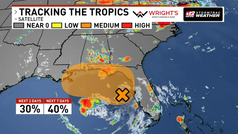
Invest 91L Brings Flooding Rain Threat to Florida as NHC Tracks Gulf System
A tropical disturbance designated Invest 91L is churning in the Gulf of America, prompting the National Hurricane Center (NHC) to issue advisories for Florida and parts of the Southeast. While the system has a low chance of developing into a named storm within 48 hours, forecasters warn that heavy rainfall—not wind—poses the primary threat to millions of residents along the Gulf Coast.
The NHC designated Invest 91L on Saturday, July 18, placing an "X" on the map to mark an area of low pressure that has formed farther from the coast than initially expected, according to the FOX Forecast Center. As of Saturday afternoon, showers and thunderstorms associated with an upper-level low and surface trough were moving slowly northward or north-northwestward. The NHC gave the system a 20 percent chance of development within 48 hours and a 30 percent chance over the next seven days.
Already, rain is falling across Florida. Showers have been reported in Tampa and along the state's northwestern coast. Forecasters urge residents along the Florida panhandle, the western coast, and coastal Alabama to monitor the disturbance closely. If Invest 91L strengthens into a tropical storm, it would receive the name Bertha, the second named storm of the 2026 Atlantic hurricane season.
Why It Matters: Rainfall and Flooding Risks Across the Southeast
Though Invest 91L lacks a well-defined surface circulation and atmospheric pressure remains relatively high—factors that limit immediate organization—the primary concern is rainfall. The National Weather Service predicts repeated rounds of storms could produce 1 to 3 inches across much of the region, with localized totals exceeding 5 inches, particularly in Florida's Big Bend area.
AccuWeather projects a broader swath of 1 to 4 inches from central Florida into southern Georgia and the Alabama and Mississippi panhandles, with isolated totals potentially reaching 8 inches. Street flooding and flooding in low-lying areas are possible across west-central and southwest Florida. The heaviest rainfall could shift west along the central Gulf Coast depending on where a low-pressure center forms and how it tracks.
The storm threat comes during a subdued start to the 2026 Atlantic hurricane season, which runs from June 1 to November 30. So far, only Tropical Storm Arthur has been named, forming near the Texas coast in mid-June with sustained winds around 45 mph before weakening over southeastern Texas and southwestern Louisiana. Arthur brought 5 to 10 inches of rain, with isolated totals near 20 inches, from Texas into parts of the Southeast, according to the NHC.
For residents, the stakes are clear: even without a named storm, days of torrential rain can cause significant flooding, disrupt travel, and endanger lives. The NHC has advised those in vulnerable areas to stay informed and prepare for potential impacts.
Broader Implications: A Below-Normal Season and Climate Trends
The emergence of Invest 91L occurs against the backdrop of NOAA's 2026 Atlantic hurricane season outlook, which predicts a 55 percent chance of a below-normal season. This forecast, issued before the season began, reflects expectations of fewer named storms than the 30-year average. However, as Invest 91L shows, even a quiet season can bring dangerous weather.
The system's slow movement and potential for prolonged rainfall align with broader trends observed in recent years: storms that stall or move slowly can dump massive amounts of water, leading to catastrophic flooding. The 2025 season, for instance, saw several slow-moving systems that caused inland flooding far from where they made landfall. Climate scientists note that warmer sea surface temperatures in the Gulf of America and a warmer atmosphere—which holds more moisture—may increase the likelihood of such heavy rainfall events.
For the region, this disturbance is a reminder that hurricane preparedness isn't only about wind and surge. "Most impacts will come in the form of rain," a FOX Weather meteorologist noted. "Wind impacts are not expected unless a tropical depression or tropical storm forms." As the system organizes or fails to organize over the next several days, the focus remains on the potential for flooding that could affect millions across the Southeast.
In a season where news cycles can shift rapidly—from outages to tragedies like the wreckage of the capsized Bay Ferry Volare near Alcatraz to celebrations like Leeds Pride 2026—the slow boil of a Gulf disturbance can easily be overlooked. Yet for those in its path, Invest 91L demands attention and respect. As the NHC continues to monitor the system, residents are urged to prepare for heavy rain and potential flooding in the days ahead.
This is a developing story. Check back for updates as the system evolves.
Comments