Heat Advisory Expands Across Central U.S. as Dangerous Heatwave Takes Hold
A sweeping heat advisory issued by the National Weather Service (NWS) is now in effect across a broad swath of the central United States, including portions of Illinois, Indiana, Kentucky, Missouri, and Alabama. The advisory, which began Sunday and extends through at least Thursday night in some regions, brings heat index values ranging from 100 to 112 degrees Fahrenheit, threatening vulnerable populations and straining power grids.
According to the NWS office in Paducah, Kentucky, a Heat Advisory was activated at noon CDT on Sunday, June 28, and will remain in effect until 8:00 PM CDT that same day, with an Extreme Heat Watch following from Monday morning through Thursday evening. The advisory covers more than 50 counties across southern Illinois, southwest Indiana, western Kentucky, and southeast Missouri. Heat index values in these areas are expected to climb between 102 and 107 degrees during the advisory period, with the Extreme Heat Watch warning of values reaching 105 to 110 degrees.
In the Tennessee Valley, the WAFF 48 weather team has declared a First Alert Weather Day for Sunday, with a Heat Advisory running through Tuesday. Forecasters there warn that additional days will likely be added as the heat and humidity persist through the July 4 holiday weekend. Feels-like temperatures in the Huntsville area are already near 105 degrees, with projections of 105 to 112 degrees during the week ahead.
Officials Urge Precautions Amid Life-Threatening Heat
The NWS has issued a clear set of precautions for residents in affected areas: drink plenty of fluids, stay in an air-conditioned room, stay out of the sun, and check on relatives and neighbors. Young children and pets should never be left unattended in vehicles under any circumstances. Those who work or spend time outdoors are advised to reschedule strenuous activities to early morning or evening, to wear lightweight and loose-fitting clothing, and to take frequent rest breaks in shaded or air-conditioned environments.
Health officials emphasize that heat-related illnesses increase significantly during extreme heat and high humidity events. Symptoms of heat exhaustion include heavy sweating, weakness, cold or pale skin, and fainting. Heat stroke, a medical emergency, is characterized by a body temperature above 103°F, hot and red skin, rapid pulse, and possible unconsciousness. Anyone overcome by heat should be moved to a cool and shaded location, and if heat stroke is suspected, 911 should be called immediately.
Why This Heatwave Matters: Stakes Are High as Heat Records Approach
This heatwave arrives at a particularly precarious time. The combination of high temperatures, elevated humidity, and the prolonged duration of the event elevates the risk of heat-related illness and mortality. Parts of western Kentucky and southeast Missouri are under an Extreme Heat Watch for much of the coming week, meaning dangerously hot conditions with heat index values of 105 to 110 degrees are possible. The persistence of this heat—extending into the July 4th holiday weekend—raises concerns about large public gatherings, outdoor celebrations, and the safety of those without access to air conditioning.
In Florida, the Tallahassee area is also experiencing intense heat. Forecasters at WTXL report that Sunday is expected to be the hottest day yet, with highs in the upper 90s and feels-like temperatures reaching 105 to 107 degrees, just slightly below Heat Advisory criteria. A ridge of high pressure is bringing drier conditions, suppressing rain chances, but an isolated shower cannot be ruled out. The heat is expected to persist through the beginning of the week, with showers and storms returning Monday and Tuesday.
A Prolonged Event: Heatwave Could Linger Through Independence Day
What distinguishes this heat event from typical summer hot spells is its duration. The NWS Paducah office noted that a prolonged period of dangerous heat and humidity is expected this coming week, and the heatwave may linger into the July 4 weekend. Similarly, the KRMS radio station reported that the National Weather Service issued a Heat Advisory in effect from noon Sunday to midnight CDT Thursday night for portions of south central, southwest, and west central Illinois, as well as central, east central, northeast, and southeast Missouri.
This extended timeline means that authorities and residents must prepare not just for a day or two of sweltering conditions, but for a sustained siege of heat that could last a week or more. The Occupational Safety and Health Administration recommends scheduling frequent rest breaks in shaded or air-conditioned environments for outdoor workers, and officials stress that anyone overcome by heat should be moved to a cool and shaded location immediately.
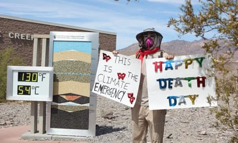
Broader Implications: Climate Trends and Infrastructure Strain
The current heat advisory fits into a larger pattern of increasingly frequent and intense heatwaves across the United States and around the world. Climate scientists have long warned that rising global temperatures are making extreme heat events more common, more severe, and longer-lasting. The fact that this heatwave is threatening to stretch through the July 4 holiday weekend is a reminder that summer heat is no longer just a seasonal inconvenience but a significant public health threat.
Infrastructure in many regions is already under strain. Power grids face increased demand as air conditioning usage spikes, and the risk of rolling blackouts rises. In urban areas, the heat island effect—where concrete and asphalt absorb and radiate heat—can make temperatures feel even higher. Vulnerable populations, including the elderly, children, and those with pre-existing health conditions, are at heightened risk. The NWS advice to check on relatives and neighbors is more than a suggestion; it is a lifeline.
How to Stay Safe and Informed
Residents in affected areas are advised to monitor local weather updates closely. The NWS recommends staying tuned to NOAA Weather Radio or local news outlets for the latest information. Heat advisories and warnings can change rapidly, and additional counties may be added as the heatwave evolves.
For those planning outdoor activities, especially around the July 4 holiday, experts recommend limiting exposure during the peak heating hours of late morning through early evening, staying hydrated, and never leaving children or pets in parked vehicles. The heat index, which combines temperature and humidity to measure how hot it feels, can be significantly higher than the actual air temperature, increasing the risk of heat stroke faster than many realize.
As the central U.S. braces for what could be one of the most intense and prolonged heatwaves of the summer, the message from meteorologists and public health officials is consistent: take the heat seriously, prepare in advance, and look out for one another.
Comments