
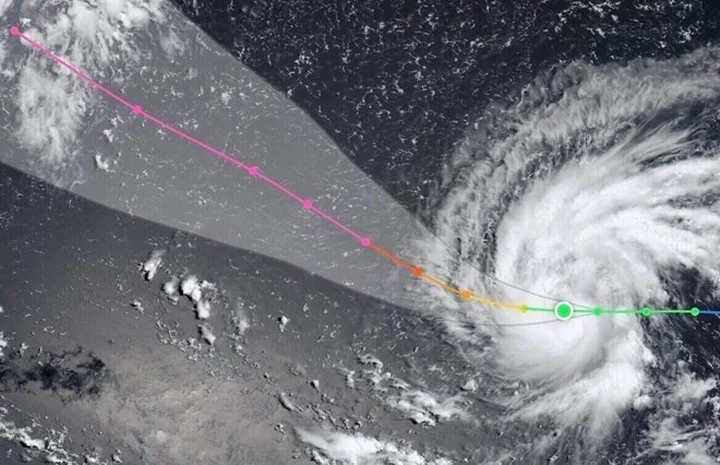
Super Typhoon Dolphin Explodes to Record Strength, Threatens China Coast
Super Typhoon Dolphin has undergone one of the most rapid intensification events ever recorded in the Western Pacific, strengthening from a tropical storm to a Category 4-equivalent super typhoon in just 24 hours. As of July 30, 2026, the storm is churning over open waters near Wake Island, packing sustained winds of approximately 200 km/h (124 mph), with forecasts warning it could peak at an extraordinary 305 km/h (190 mph) by July 31. That would make Dolphin the strongest storm on Earth in 2026, potentially rivaling historical July monsters like Typhoon Nepartak (2016) and even Typhoon Wanda (1956).
The Joint Typhoon Warning Center (JTWC) and Japan Meteorological Agency are tracking Dolphin as it moves west-northwest at 20 km/h. Current projections show the storm curving toward the Fujian-Zhejiang coast of China, with landfall possible around August 5–7. While the storm is not expected to enter the South China Sea, its outer bands will draw in the southwest monsoon, whipping up dangerous seas and gusty winds across southern Vietnamese waters and the broader East Sea region starting August 5.
Rapid Intensification Shatters Records
Dolphin’s explosive growth has stunned meteorologists. At 2 a.m. Manila time on July 29, the storm’s one-minute sustained winds surged by 150 km/h in a single day — the fastest 24-hour intensification in the Western Pacific since Typhoon Noru in 2022. By the evening of July 28, it had already jumped from a Category 1 to a Category 3 equivalent, becoming a major typhoon within hours.
Satellite imagery reveals a perfectly symmetrical eye, a hallmark of a storm encountering no atmospheric or oceanic resistance. The JTWC predicts Dolphin will reach Category 5 intensity by July 31, with winds of 305 km/h. If that forecast holds, Dolphin would surpass Super Typhoon Sinlaku, which devastated Guam in April 2026, as the year’s most powerful cyclone globally.
Where Is Super Typhoon Dolphin Now? Live Tracker and Forecast
As of the morning of July 30, Dolphin was centered at approximately 16.4°N, 165.8°E — about 715 km southeast of Wake Island and roughly 6,000 km east of Vietnam. The storm is moving west-northwest at 15–20 km/h over the next three days, before turning more westward toward the Chinese coast.
Forecasters caution that while the storm’s core will remain over open ocean through at least August 4, the wind field is enormous. A New York Times tracking map shows a high probability of damaging winds (over 58 mph) reaching parts of Taiwan, eastern China, and the Ryukyu Islands by early next week. The storm’s rainbands could also dump 5 to 10 inches of rainfall — with local amounts exceeding 10 inches — triggering flash flooding well inland.
Monsoon Surge Threatens Vietnam
Vietnam’s National Center for Hydro-Meteorological Forecasting issued a special advisory on July 30, warning that while Dolphin will not directly enter the East Sea (South China Sea), it will strengthen the southwest monsoon as it passes north of Taiwan. This means heightened winds and rough seas across the southern East Sea from August 5 onward, though no direct coastal impacts are expected through August 4. Fishermen and offshore operators have been urged to monitor conditions closely.
Why This Storm Matters: The Stakes of a Record-Breaking Cyclone
Dolphin is not just another typhoon. Its rapid intensification — a phenomenon increasingly linked to warmer ocean waters — raises urgent questions about preparedness in some of the world’s most densely populated coastal regions. The storm threatens China’s Fujian and Zhejiang provinces, home to tens of millions of people and major economic hubs like Shanghai (though the city is currently outside the direct track cone).
The parallels to Typhoon Nepartak (2016) are striking. Nepartak also underwent rapid intensification before slamming into Taiwan and eastern China, causing $1.8 billion in damages and killing 86 people. If Dolphin maintains its projected strength, it could become the strongest July typhoon to hit mainland China in decades.
Rapid Intensification: A Climate Alarm
The 2026 Pacific typhoon season has already featured three super typhoons — Sinlaku, Mekkhala, and Bavi — before Dolphin’s arrival. The frequency and speed of such storms fit a pattern scientists have warned about: as sea surface temperatures rise, the atmosphere holds more moisture, providing fuel for explosive development. Dolphin’s 150 km/h leap in 24 hours is a textbook example of what climatologists call “rapid intensification,” a trend that has become more common since 2000.
According to the National Oceanic and Atmospheric Administration (NOAA), the Western Pacific has seen a 50% increase in the number of storms that strengthen by at least 35 mph in 24 hours over the past four decades. Dolphin may now hold the record for the fastest such jump in the basin.
Typhoon Season Is Year-Round
While July through December is the historical peak for typhoons, the 2026 season underscores that storms can form at any time. Sinlaku’s devastating April landfall on Guam — causing billions in damage — was a stark reminder that tropical cyclones are no longer confined to traditional seasons. Dolphin’s July intensity also shatters a commonly held assumption that early-season storms are weaker.
The storms that strike the Philippines, Japan, Taiwan, Korea, China, Vietnam, and U.S. Pacific territories are becoming more unpredictable and powerful. The Joint Typhoon Warning Center has improved its tracking models, but the challenge of forecasting rapid intensification remains significant.
What the Broader Trends Mean for the Region
Dolphin’s trajectory and intensity have implications far beyond the immediate wind field. The storm is a case study in how atmospheric dynamics are shifting in a warming world, and it forces governments — and individuals — to rethink disaster readiness.
Economic Exposure: China’s Coast in the Crosshairs
Fujian and Zhejiang are manufacturing and trade powerhouses, with billions of dollars in port infrastructure, electronics factories, and agriculture. A direct hit from a super typhoon of Dolphin’s potential strength could disrupt global supply chains, particularly in semiconductors and consumer goods. The port of Ningbo-Zhoushan, one of the world’s busiest, is within the forecast cone’s outer probability zone. Even if the storm veers north, the associated storm surge and flooding could shut down operations for days or weeks.
In Vietnam, while the storm itself will not make landfall, the monsoon surge it triggers could affect offshore oil and gas platforms, fishing fleets, and coastal tourism. The country is still recovering from Typhoon Sinlaku’s indirect impacts earlier this year. Vietnam’s meteorological agencies have emphasized that the storm will churn waters at a distance, but the invisible threat of increased swells and rip currents should not be underestimated.
Humanitarian and Infrastructure Challenges
Taiwan, which sits on the northern edge of the forecast cone, is no stranger to typhoons. However, rapid intensification events leave little time for evacuation or for reinforcing vulnerable infrastructure like power grids and sea walls. The most damaging storms of the past decade in Taiwan — Nepartak, Soudelor, and Morakot — all intensified quickly, catching some communities off guard.
The Philippines, while not in Dolphin’s immediate path, often suffers from the Southwest Monsoon (Habagat) being enhanced by distant typhoons. Heavy rain and flooding could affect the western parts of Luzon even if the storm stays a thousand kilometers away.
A Test for Forecast Technology
The accurate prediction of rapid intensification remains one of the hardest problems in meteorology. Dolphin’s explosive growth was not fully captured by all models 72 hours prior. However, improvements in satellite technology, including real-time microwave imagery from the Japanese Himawari-9 satellite, allowed the JTWC to issue the upgrade to super typhoon status with greater confidence than in previous years.
Conclusion: A Storm That Rewrites Records and Risks
Super Typhoon Dolphin is not just another weather event. It is a harbinger of what is becoming the new normal in the Pacific — storms that explode in power with breathtaking speed, threatening some of the most economically and demographically significant regions on Earth.
Whether Dolphin makes landfall as a Category 5, veers out to sea, or weakens slightly before reaching shore, it has already etched its name into the historical record. The next 72 hours will be critical for millions of people from Taiwan to China to Vietnam.
For now, residents in the affected areas should monitor official updates from their national meteorological agencies and prepare for potentially life-threatening conditions. As the AI Speed Cameras Surge: Privacy Fears as Fines Top $1.1M in One Town story shows, technology can both help and disrupt — and with Dolphin, high-tech tracking is the best defense against nature’s most violent forces.
Stay tuned for further updates on Super Typhoon Dolphin’s path and intensity.
Comments