
Twin Hurricanes Hawaii Trend Resurfaces as Olana's Remnants Threaten Flooding
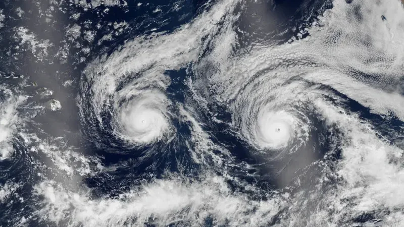
As Hawaii braces for days of torrential rain and potential flash flooding from the remnants of Tropical Storm Olana, a decade-old satellite image of twin hurricanes Madeline and Lester converging on the islands has resurfaced online, sparking confusion and speculation about whether the Aloha State is facing a similar dual-storm scenario now. The image, captured by the Suomi NPP satellite on August 29, 2016, shows the two powerful hurricanes side by side as they churned toward Hawaii—a rare meteorological event that ultimately spared the islands from direct landfall but delivered strong winds, heavy rain, and dangerous surf.
The resurfacing of that striking imagery comes as the Central Pacific is under a different kind of threat: a week-long siege of tropical moisture funneled northward by the remnants of Olana, which was downgraded from a tropical storm to a remnant low earlier this week. The entire island chain remains under a Flood Watch through Wednesday night, with forecasters warning of 5 to 8 inches of rain, mudslides in high-elevation areas, and coastal flooding. The juxtaposition of the viral 2016 image with the current flood threat has created a perfect storm of misinformation and heightened public anxiety—even though no twin hurricanes are currently approaching Hawaii.
What the 2016 Image Actually Shows
The satellite photograph that has recirculated on social media this week captures Hurricane Madeline on the left and Hurricane Lester on the right, both on a similar track toward Hawaii's Big Island. At the time, Madeline was the 14th named storm of the 2016 Pacific hurricane season, and Lester was the 13th. The season would eventually tie for the sixth-most-active on record with 22 named storms, according to meteorological records.
By August 30, 2016, Madeline had peaked as a Category 4 hurricane with maximum sustained winds of approximately 130 mph (210 km/h), while Lester trailed about 900 miles behind on a similar trajectory. Madeline was just under 400 miles from the Big Island that day—close enough that the Central Pacific Hurricane Center issued a hurricane warning and cautioned that the storm would pass dangerously close to the island. Meteorologists at the time were uncertain whether either storm would make landfall, creating a tense waiting period for residents.
Ultimately, neither hurricane struck Hawaii directly. Madeline weakened to a Category 1 storm and passed south of the islands on August 31. Lester briefly intensified to Category 4 on September 1 before weakening to Category 3 and passing north of the Big Island two days later, skimming within about 130 miles of Honolulu before turning sharply northward and dissipating. Despite avoiding direct hits, both storms brought high winds, heavy rainfall, and elevated surf to the state.
Current Threat: Olana's Remnants and a Week of Severe Weather
While the 2016 image tells a story of a near-miss, Hawaii's present-day weather situation is driven by an entirely different system. Olana, which was briefly upgraded to a tropical storm on Sunday, has since transitioned to a tropical depression and then a remnant low. However, its remnants are interacting with a deep reservoir of tropical moisture and Hawaii's complex mountainous terrain to generate widespread heavy showers and thunderstorms.
According to the FOX Forecast Center, the former system is encountering hostile environmental conditions—increasing vertical wind shear and dry mid-level air—but is still expected to draw deep tropical moisture across the Hawaiian Islands from Tuesday through Thursday. The storm system will be far from the islands by midweek, but the moisture surge will interact with the terrain to force air upward, triggering prolonged storms and heavy rain over two to three days.
"Flash flooding also brings the risk of mudslides in high-elevation areas, as 5 to 8 inches of rain is possible," FOX Weather reported. The heaviest rain is expected to sweep from the south and west-facing slopes of the islands, creating varying effects across different landscapes depending on the direction the rain lashes. Wind gusts are also expected to increase as the system becomes more organized.
This comes as the entire island chain is under a Flood Watch through Wednesday night, with forecasters warning of serious flash flood risk. The situation is compounded by the fact that the ground in many areas is already saturated, and additional heavy rainfall could quickly lead to runoff and flooding in low-lying areas.
The Role of Climate Change and El Niño
While the 2016 twin hurricanes and the current Olana remnants are separate events, both underscore a broader trend: Hawaii's historical good fortune in dodging the worst effects of hurricanes may not hold indefinitely. The islands often sit amid a high-pressure area that serves as a protective barrier, coupled with prevailing eastward winds that push storms away from land. However, with climate change fostering increased occurrences of extreme weather events and altering regional climate patterns, concerns are mounting about the potential for increased hurricane impacts in the future.
Recent hurricanes such as Lowell and Lala have drawn attention, causing damage to power lines and coastal infrastructure as they passed unusually close to Kauai. Researchers suspect that the ongoing "super" El Niño phenomenon—which officially began in May and is linked to record sea surface temperatures in the Pacific—may be exacerbating storm activity in the region. The evolving climate scenarios suggest that the islands' historical buffer may be weakening, prompting heightened awareness and readiness for potential future hurricane events.
Context: Why the Viral Image Matters Now
The recirculation of the 2016 satellite image during a real-time flood threat highlights the challenges of communicating weather risk in the social media age. The image, which shows an eerie resemblance to a face gazing upward due to the symmetric formation of the two storms, is visually striking and easily shared without context. For residents already anxious about the current Flood Watch, the image can create confusion about whether two hurricanes are currently bearing down on the islands.
In reality, no tropical activity is expected in the Atlantic in the next seven days, according to Bryan Norcross of FOX Weather—though that assessment pertains to the Atlantic basin, not the Central Pacific. The current threat to Hawaii is entirely from the remnants of Olana, a much weaker system that nonetheless poses a serious flood risk due to its moisture-laden nature and the islands' mountainous terrain.
The 2016 season remains a benchmark for Hawaii's hurricane preparedness. The double approach of Madeline and Lester prompted widespread warnings and evacuations, and although the storms ultimately spared the islands, the event demonstrated the importance of early warning systems and public awareness. The Central Pacific Hurricane Center's decision to issue a hurricane warning for Madeline—despite uncertainty about its exact track—reflected a cautious approach that prioritized safety over certainty.
Perspective: A Changing Climate and a More Vulnerable Hawaii
The juxtaposition of the 2016 twin hurricanes and the current Olana remnants offers a window into a broader narrative about Hawaii's vulnerability to extreme weather. Historically, the islands have been fortunate, with high-pressure systems and prevailing winds acting as natural shields. But climate change is altering those patterns, and the region is experiencing more frequent and intense storms.
The 2016 Pacific hurricane season was one of the busiest on record, with 22 named storms. That activity was linked in part to a strong El Niño event, which warmed sea surface temperatures in the Pacific and fueled storm development. The current "super" El Niño, which began in May, is similarly raising concerns about increased hurricane activity in the region. While the current threat from Olana is a flood event rather than a hurricane, it is a reminder that Hawaii's weather is becoming more extreme.
Moreover, the warming of the ocean—driven by climate change—is expanding seawater and contributing to more coastal flooding on sunny days, as evidenced by the King Tide flooding currently affecting the Southeast coast of the United States. While that specific event is occurring thousands of miles away, the underlying mechanism—warmer oceans holding more energy and expanding—is global. For Hawaii, this means that even non-hurricane systems like Olana can produce disproportionate impacts when combined with already elevated sea levels and saturated ground.
As the islands continue to recover from the current flood threat, the 2016 image serves as both a historical curiosity and a cautionary tale. It reminds us that Hawaii's location in the Pacific hurricane corridor makes it inherently vulnerable, and that the buffer that has protected the islands for so long may be eroding. For now, residents are focused on the immediate threat: days of heavy rain, potential mudslides, and the possibility of flash flooding. But the longer-term question—whether Hawaii is prepared for a future in which twin hurricanes are not just a viral image from the past but a recurring reality—remains unanswered.
What to Watch For
Forecasters are urging residents to monitor local flood alerts and avoid driving through flooded roads, as saltwater and debris can cause significant damage to vehicles. The Flood Watch remains in effect through Wednesday night, with the heaviest rain expected Tuesday through Thursday. Beyond that, the Central Pacific Hurricane Center is not tracking any additional tropical systems that pose an immediate threat to the islands, but the season is far from over.
For those following the viral image, the key takeaway is clear: the twin hurricanes of 2016 are a memory, not a current event. The real story is Olana's remnants and the flood risk they pose—a story that, while less visually dramatic, is far more relevant to the safety of Hawaii's residents today.
Comments