
Super El Niño 2026 Intensifies: A Historic Weather Event Takes Shape
Forecasters are closely monitoring a rapidly strengthening El Niño in the tropical Pacific, with conditions on track to reach 'Super' status by late 2026. Current ocean temperature anomalies in the Niño 3.4 region—the key monitoring zone used by climate agencies—are already 1.5°C above average, placing the event in the 'strong' category. To officially qualify as a Super El Niño, temperatures must exceed 2°C above normal for a sustained three-month period.
According to the FOX Forecast Center, the trajectory suggests this threshold will likely be crossed this fall or winter. If current model projections hold, the 2026 El Niño could rival or surpass the historic 1997 event, potentially becoming the strongest ever recorded. The Climate Prediction Center (CPC) has already adjusted its seasonal outlook, anticipating above-average precipitation across the Southeast, the Four Corners region, and the Southwest from September through November.
A Second Ocean Anomaly Emerges
Adding to the complexity, a new ocean anomaly known as the positive Indian Ocean Dipole (IOD) is emerging in the Indian Ocean. Unlike El Niño's uniform warming across the eastern Pacific, the positive IOD creates opposing temperature gradients: warmer-than-average waters in the west and cooler-than-average waters in the east. This temperature imbalance drives a massive atmospheric circulation shift, with rising air over the warm western basin and sinking air over the cooler east.
Seasonal forecast models indicate the positive IOD phase could persist through fall and into early winter. This creates a rare and significant scenario: a Super El Niño and a positive IOD operating simultaneously. Climate scientists describe this as a fully connected, dual-ocean atmospheric system, where tropical forcing from both basins synchronizes to influence jet stream patterns across the Northern Hemisphere.
Why This Matters: A Dual-Ocean Engine for Winter 2026/2027
The combination of a Super El Niño and a positive IOD is not merely a scientific curiosity—it is a major driver of global weather patterns. These ocean anomalies work together to alter the position and strength of the Pacific jet stream, which in turn steers storm tracks and temperature regimes across North America and Europe.
For the United States, this typically means a wetter and cooler winter across the southern tier, from California through the Southeast, while the Pacific Northwest and parts of the Midwest often experience drier and warmer conditions. The positive IOD can amplify these effects, potentially intensifying precipitation in already vulnerable regions. The latest long-range forecasts for Winter 2026/2027 suggest the combined forcing could produce significant snowfall events in the Sierra Nevada and Rocky Mountains, as well as increased storm activity across the Gulf Coast states.
The Hurricane Season Connection
El Niño's influence extends into the Atlantic hurricane season, and the 2026 season is already reflecting this. NOAA's final outlook, released in early August, calls for a below-average season with 7 to 13 named storms, 2 to 6 hurricanes, and 0 to 2 major hurricanes (Category 3 or stronger). This forecast includes the two named storms that have already formed—Arthur and Bertha—and represents a reduction from the initial May outlook.
NOAA raised the probability of a below-average season from 55% to 75%, citing the strong El Niño's enhancement of vertical wind shear over the Atlantic. This shear disrupts the organized convection needed for tropical cyclone development. The pattern is a stark contrast to the recent hyperactive seasons of the last decade, most of which featured above-average activity.
The Global Stakes: Record Temperatures and Extreme Weather
The stakes of a Super El Niño extend far beyond seasonal forecasts. Historical precedent from the 1997 and 2015/2016 events shows that such extreme El Niños produce cascading global impacts, including severe droughts, flooding, and disruptions to agriculture and marine ecosystems. The 1997 event, the current record-holder, was associated with massive coral bleaching, significant storm activity in the Pacific, and widespread weather anomalies.
A 2026 event of similar or greater magnitude would likely exacerbate these risks. The warming of the central and eastern Pacific often leads to an active Eastern/Central Pacific hurricane season, while suppressing Atlantic activity. This year has already demonstrated that pattern, with an active hurricane season in the Pacific and limited development in the Atlantic.
Impact on Fisheries and Food Security
The ocean temperature changes associated with Super El Niño also have profound effects on marine life. The disruption of upwelling currents along the South American coast can lead to dramatic declines in fish populations, impacting local economies that depend on fisheries. These impacts, combined with the potential for drought and flooding in agricultural regions, raise concerns about global food security. Previous reporting has highlighted the risk that El Niño conditions could push 49 million more people into acute hunger by 2027.
What To Expect: A Winter Shaped by Tropical Forcing
As atmospheric scientists analyze the latest model runs, the core message is that the 2026/2027 winter will be significantly influenced by this dual tropical forcing. For the United States and Canada, the presence of a Super El Niño typically correlates with a pronounced shift in the polar vortex and the jet stream. The positive IOD can modulate these effects, sometimes strengthening the connection between tropical convection and mid-latitude weather.
The European outlook is more variable, but a strong El Niño often brings wetter conditions to southern Europe and drier, colder spells to the north. When combined with a positive IOD, forecasters often see an increased likelihood of blocking patterns, which can lead to prolonged cold air outbreaks or extended rainfall periods depending on the exact positioning of high-pressure systems.
Preparing for High-Impact Events
For emergency managers and the public, the key takeaway is preparedness. The most severe impacts from a Super El Niño are typically felt in the fall and winter months. This means the potential for intense winter storms, flooding in the southern United States, and significant snowfall in mountain regions should be considered in planning.
Long-range forecasts, while not deterministic, are consistent in signaling an active and potentially severe winter for many parts of the Northern Hemisphere. The combination of a historically strong El Niño and a concurrent positive IOD raises the confidence in these outlooks, even at extended lead times.
A Changing Climate Context
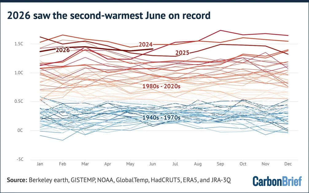
The emergence of a potential record-breaking Super El Niño also occurs against a backdrop of ongoing global warming. Ocean temperatures overall are higher than in previous decades, which can exacerbate the impacts of natural climate cycles. The months leading up to this event have already been characterized by unusual weather phenomena, including a notable solar eclipse event in the UK in August 2026.
This year's event serves as a real-world test for existing climate models and forecasting capabilities. While the underlying mechanisms of El Niño are well understood, the interaction between a Super El Niño and a positive IOD on a warmer planet is an area of active research. The outcome of this winter will offer valuable data that could reshape our understanding of how these large-scale ocean-atmosphere interactions behave in a changing climate.
Forecasters will continue to monitor the Niño 3.4 region and IOD indices over the coming weeks, looking for confirmation of the super status and the persistence of the positive dipole. The next few months will be critical in determining the exact trajectory and ultimate impact of what could be a historic global weather event.
Comments