NASA Satellite Reveals Mexico City Sinking at Alarming Rate
New satellite imagery from NASA, released this week, has confirmed that Mexico City is sinking by nearly 10 inches (25 centimeters) annually, making it one of the fastest-subsiding major cities on Earth. The data, captured between October 2025 and January 2026 by the NISAR satellite—a joint mission between NASA and the Indian Space Research Organization—shows that the ground beneath the Mexican capital is collapsing at an average rate of 0.78 inches (2 centimeters) per month.
In some areas, the subsidence reaches up to 20 inches per year, according to researchers at the National Autonomous University of Mexico (UNAM). Over the past century, parts of the city have sunk more than 39 feet (12 meters). The phenomenon is so dramatic that it is now visible from space, with satellite imagery documenting the deformation of the landscape in real time.
“It damages part of the critical infrastructure of Mexico City, such as the subway, the drainage system, the water, the potable water system, housing and streets,” said Enrique Cabral, a geophysics researcher at UNAM. “It’s a very big problem.”
The findings have reignited global concern over the city’s chronic water crisis, which has been escalating for decades. With a metro area population exceeding 22 million, Mexico City is the largest urban center in North America, surpassing Los Angeles and New York. Yet its very foundation—built atop an ancient lake bed—is literally giving way beneath it.
Why Mexico City Is Sinking: Groundwater and Geology
The primary driver of the sinking is the relentless extraction of groundwater from the aquifers beneath the city. Originally founded as the Aztec capital Tenochtitlan on an island in Lake Texcoco in 1325, Mexico City was built on soft, water-saturated clay and volcanic sediments. After the Spanish conquest, the lake was gradually drained to make way for urban expansion, but the underlying aquifer remained a critical water source.
Today, approximately 70% of the city’s water supply comes from these underground reserves. As the population has grown and climate change has intensified drought conditions, the rate of pumping has far exceeded the natural recharge rate of the aquifer. The result is that the ground compacts like a squeezed sponge, causing the land surface to drop.
“We have one of the fastest velocities of land subsidence in the whole world,” Cabral stated. The problem was first documented by an engineer in 1925, and by the 1990s and early 2000s, some districts were sinking as much as 14 inches (35 centimeters) annually. While modern pumping regulations have slowed the rate slightly, new satellite data shows the city is still subsiding at an average of 9.5 inches per year.
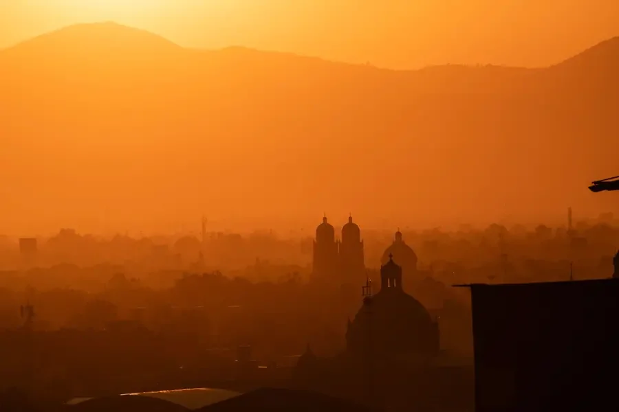
Landmarks Show the Toll
The effects are visible in some of Mexico City’s most iconic structures. The Metropolitan Cathedral, which began construction in 1573 and incorporates stones from Aztec temples, now leans noticeably to one side. The Basilica of Our Lady of Guadalupe, another major landmark, has an unlevel foundation that is clearly visible in photographs. The Angel of Independence monument, erected in 1910 to mark 100 years of Mexico’s independence, has had 14 steps added to its base over the years as the ground has sunk around it.
Other critical infrastructure is also at risk. The city’s subway system, drainage networks, and water pipelines are all being deformed by uneven sinking. In some neighborhoods, streets crack and buildings tilt, forcing residents to adapt to a landscape that shifts under their feet.
The Water Crisis: A Vicious Cycle
The subsidence is not just a structural problem—it is inextricably linked to the city’s worsening water crisis. As the aquifer is depleted, the ground sinks, which in turn damages the very pipes and pumps needed to bring water to residents. This creates a feedback loop: more water is lost through broken infrastructure, leading to even more groundwater extraction, which accelerates the sinking.
Mexico City has experienced severe water shortages in recent years, with some neighborhoods receiving water only a few hours per week. The crisis has been exacerbated by climate change, which has reduced rainfall and increased evaporation rates across the region. In 2025, the government declared a water emergency in several districts, and experts warn that the situation will only intensify.
“The shrinking aquifer has also contributed to a chronic water crisis that is only expected to worsen,” according to the Los Angeles Times report. The government has announced funding for research into solutions, including rainwater harvesting, wastewater recycling, and reducing reliance on the aquifer. However, the sheer scale of the problem—affecting 22 million people spread across 3,000 square miles—makes comprehensive solutions difficult to implement.
A Century of Sinking
To understand the magnitude of the problem, consider this: over the past 100 years, the city has dropped more than 39 feet. That is roughly the height of a four-story building. For residents living in areas like Iztapalapa, a densely populated borough on the eastern edge of the city, the sinking has become a daily reality. Homes crack, streets buckle, and the drainage system struggles to carry away rainwater, leading to frequent flooding during the rainy season.
Cabral and his team at UNAM have been monitoring the subsidence for years, but the NISAR satellite data provides unprecedented detail. “You can see the full magnitude of the problem,” said NISAR scientist Paul Rosen. The satellite uses radar to map changes in the Earth’s surface with centimeter-level accuracy, allowing researchers to track movement even on a building-by-building scale in the future.
Broader Implications: A Warning for Other Cities
The crisis in Mexico City is not an isolated phenomenon. Many rapidly growing cities around the world—particularly those in river deltas or on former lake beds—face similar challenges. Jakarta, Bangkok, Venice, and parts of California’s Central Valley all experience significant subsidence due to groundwater extraction and urban development.
But Mexico City’s case is particularly stark because of its size and history. The city is built on a former lake, which means the ground is exceptionally compressible. As the population continues to grow and climate change intensifies droughts, the pressure on the aquifer will only increase. If current trends continue, some models suggest that parts of the city could sink an additional 20 to 30 feet by the end of the century.
The implications for infrastructure are enormous. The subway system, which carries millions of passengers daily, is already showing signs of stress. Drainage systems designed decades ago are no longer at the correct gradient, causing backups and flooding. Water mains break more frequently, and the cost of repairs is soaring.
What Can Be Done?
There is no easy fix. Reducing groundwater extraction is essential, but the city currently has no alternative water source that can meet the needs of 22 million people. Some proposals include importing water from more distant rivers, building desalination plants, or investing heavily in rainwater capture. The government has also considered injecting water back into the aquifer to help stabilize the ground, a technique used in some other sinking cities.
In the meantime, the city is adapting. Engineers are designing new buildings with foundations that can accommodate uneven settling. Roads and subway lines are being reinforced. But the challenge is immense, and for many residents, the immediate concern is simply getting enough water to drink.
The NASA satellite data has given scientists and policymakers a powerful tool for monitoring the problem. By tracking subsidence in real time, they can identify the most vulnerable areas and prioritize repairs. But Rosen cautioned that the data also reveals the limits of what can be achieved. “It’s basically documentation of all of these changes within a city,” he said. “But documenting is not the same as solving.”
Conclusion: A City at a Crossroads
Mexico City stands at a crossroads. The sinking is not going to stop anytime soon, and the water crisis is likely to deepen as climate change accelerates. For the 22 million people who call this metropolis home, the only way forward is to accept that the ground beneath them is shifting—and to invest in the infrastructure and policies needed to keep the city livable.
Other cities facing similar pressures would do well to watch closely. As NASA’s NISAR satellite continues to map the Earth’s surface, it will provide an ever-clearer picture of just how fast the world’s urban centers are subsiding. For now, the message from Mexico City is clear: what lies beneath matters as much as what stands above.
For more on infrastructure challenges, read about how the Jet Fuel Crisis Grounds Spirit Airlines, Threatens Summer Travel Chaos or how the UK Housing Market Shows Tentative Signs of Recovery as Affordability Crisis Deepens in Spring 2026.
Comments