Strengthening El Niño Raises Alarms for Extreme Weather Worldwide
Just one month into the Atlantic hurricane season, the tropics have gone eerily quiet. Only one named storm—Arthur, which formed on June 17—has emerged, putting the season a week behind schedule. The culprit? A rapidly strengthening El Niño that is already reshaping weather patterns across the globe. On July 3, 2026, the World Meteorological Organization (WMO) issued a stark update: El Niño conditions have developed in the tropical Pacific and are forecast to intensify quickly, with a high probability of becoming a "super El Niño" by winter.
Forecast models from leading global centers show remarkable agreement, pointing to seasonal-average sea-surface temperature anomalies exceeding 2°C in key monitoring regions during July-September. The WMO's Global Seasonal Climate Update indicates a rapid development into a strong event, with El Niño expected to peak between November and February. This is not just another climate cycle—it could be one of the most powerful El Niño events dating back to 1950, according to the Climate Prediction Center.
The implications are immediate: suppressed Atlantic hurricane activity now, but heightened risks of heatwaves, droughts, and heavy rainfall later. The FOX Forecast Center notes that El Niño is intensifying faster than initially predicted, and its effects will cascade through global weather systems.
The Science Behind the Super El Niño Forecast
El Niño is a natural climate phenomenon that disrupts normal Pacific trade winds. When trade winds weaken, warm water that normally accumulates near Asia flows back toward the Americas, shifting the Pacific jet stream and altering global weather. The current event is unusual not just for its strength but for its speed of development.
Record Ocean Heat Amplifies the Threat
June 2026 saw the highest ocean surface temperatures ever recorded, hitting an average of 20.98°C, according to the European Union's Copernicus Marine Service. This record-breaking ocean heat wave is not limited to the Pacific—it is worldwide. The northern Pacific, in particular, is experiencing a massive heat wave, with visible consequences on beaches along the U.S. West Coast.
"El Niño conditions are already underway and are forecast to strengthen rapidly into a strong event, as accurately anticipated by WMO forecasts," said WMO Secretary-General Celeste Saulo. "This will intensify the chances of drought and heavy rainfall and the risk of heatwaves on land and marine heatwaves in many regions of the world."
What Forecasters Are Predicting
NOAA estimates a 63% chance that sea-surface temperatures in the central and eastern Pacific will rise 2°C or more above historical averages between November 2026 and January 2027—a threshold that would qualify as a "super El Niño." Such an event could fuel the hottest year on record, building on months of extreme heat that have already blanketed the Northern Hemisphere.
Atlantic Hurricane Season: A Temporary Lull with a Hidden Danger
For now, the Atlantic hurricane season is experiencing a paradoxical calm. Strengthening El Niño creates hostile upper-level winds that tear apart developing tropical systems. The FOX Forecast Center shows wind shear increasing across the Atlantic, and the Climate Prediction Center projects an 80% chance of below-average precipitation in the Main Development Region of the Caribbean.
However, meteorologists warn that this quiet period could be deceiving. The same El Niño that suppresses Atlantic storms can also fuel powerful Pacific typhoons and influence storm tracks globally. The average 'C' named storm typically arrives by July 6, but the National Hurricane Center forecasts no tropical activity for at least the next week. Yet when El Niño strengthens, it can later shift atmospheric patterns, potentially steering storms toward land.
The Risk of Extreme Weather Events
The WMO's update emphasizes that El Niño's impacts go beyond hurricanes. The phenomenon is linked to a cascade of extreme weather, including:
- Severe droughts in Southeast Asia, Australia, and parts of Africa
- Heavy rainfall and flooding in the southern United States, South America, and East Africa
- Marine heatwaves that devastate coral reefs and fisheries
- Increased wildfire risk as dry conditions combine with record heat
Global Impacts: From Heatwaves to Wildfires
The current El Niño forecast comes on the heels of a June that saw extreme heat alerts across Europe and the U.S. as the July 4 weekend began. The Tour de France 2026 is now facing historic heatwave threats, with riders competing in dangerously high temperatures.
The UN Secretary-General António Guterres warned in June that "El Niño conditions will pour fuel on the fire of a warming world." This year's event is unfolding against a backdrop of already elevated global temperatures, making its impacts even more severe.
Agriculture Under Pressure
Farmers across the Northern Hemisphere are bracing for unpredictable conditions. The super El Niño forecast suggests that planting and harvest cycles could be disrupted, with some regions facing drought while others deal with excessive rainfall. Global food supply chains, already strained by recent geopolitical tensions, could face additional shocks.
Public Health Concerns
Heatwaves driven by El Niño can lead to heat-related illnesses, wildfires that degrade air quality, and the spread of vector-borne diseases like dengue fever. The WMO has mobilized its community to provide early warnings and climate services to help vulnerable populations prepare.
The Role of Climate Change in Super El Niño Events
While El Niño is a natural cycle, scientists are increasingly linking its intensity to climate change. Warmer baseline ocean temperatures mean that when an El Niño develops, it starts from a higher thermal foundation, making extreme events like the current one more likely.
The record-setting ocean heat wave of June 2026 is a stark indicator. Global average sea-surface temperatures have climbed year after year, breaking records previously set in 2023 and 2024. This excess heat energy is a fuel source for more powerful storms and longer-lasting heatwaves.
A Changing World
The current El Niño forecast is not just a seasonal weather story—it is a signal of broader systemic change. The combination of a super El Niño and record ocean heat creates conditions for unprecedented weather chaos. As one analyst put it, "It feels like we are living through a Hollywood disaster movie."
What to Expect in the Coming Months
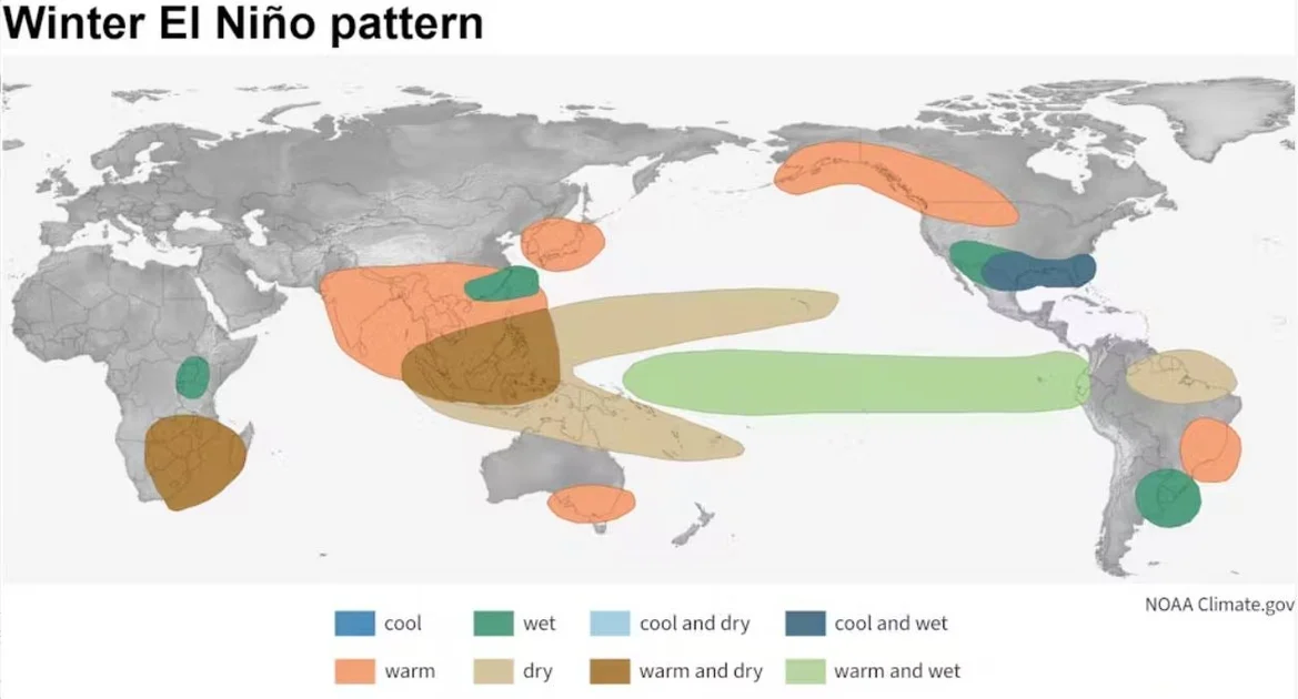
Forecasters expect El Niño to continue strengthening through autumn, reaching peak intensity in Northern Hemisphere winter. For the United States, this means a cooler and wetter winter for the southern half of the country—a stark contrast to the extreme heat of summer.
Globally, the WMO expects increased likelihood of:
- Heatwaves in Asia and Europe
- Drought in Australia, Indonesia, and parts of Africa
- Heavy rain in eastern Africa, South America, and the southern U.S.
- Marine heatwaves in the Pacific and Atlantic oceans
The Winds of Change
For now, the Atlantic remains quiet, but the winds that suppress hurricanes today will later drive storms elsewhere. The same El Niño that silences the Atlantic can amplify the Pacific typhoon season, potentially leading to more intense storms in Asia.
As the world watches, the El Niño forecast serves as a reminder that weather patterns are interconnected. A super El Niño does not just change temperatures—it reshapes ecosystems, economies, and lives. The next few months will test the resilience of communities and the preparedness of governments.
Conclusion: A Defining Moment for Global Weather
The El Niño forecast for 2026 is extraordinary in its strength and speed. With a super El Niño likely, the world faces a period of heightened weather extremes that could set new records for heat, drought, and rainfall. The Atlantic hurricane season may be delayed, but the broader impacts will be felt for months to come.
As meteorologists continue to monitor the situation, one thing is clear: this is not a normal year. The combination of a rapidly strengthening El Niño, record ocean heat, and a warming planet creates a perfect storm for weather chaos. Whether it brings needed rain to drought-stricken areas or devastating floods to vulnerable communities, the super El Niño forecast is a call to action for early warning systems and disaster preparedness.
Meanwhile, on the home front, the quiet Atlantic may offer a false sense of security. As the FOX Forecast Center notes, the belt of hostile winds now suppressing storms could later shift, unleashing fury when least expected.
For those fascinated by atmospheric phenomena, the current El Niño also offers a rare opportunity to witness the power of natural climate cycles, albeit with serious consequences. And just as the Northern Lights Forecast: 19 US States to See Aurora Borealis Tonight showcases the beauty of space weather, El Niño reminds us that our planet's weather is equally dynamic—and increasingly dangerous.
Comments