
Winter Weather Warning: Super El Niño Poised to Disrupt Winter 2026/2027
As the final days of summer 2026 wind down, meteorologists are already turning their attention to the months ahead. The focus is on a powerful Super El Niño that has developed in the Pacific Ocean, which is expected to significantly influence weather patterns across North America and Europe this coming winter. Early forecasts from Severe Weather Europe indicate that this event could create a sharp divide in temperature and precipitation, with some areas bracing for intense cold and heavy snow, while others may experience a milder than usual season.
This winter weather warning comes after a summer of extremes, including thunderstorms and flooding in the UK, and just months after a punishing winter (2025/26) brought blizzards and major disruptions to the U.S. The upcoming season is shaping up to be equally, if not more, dramatic, with the El Niño signal already showing exceptional strength in ocean temperature data.
The Super El Niño Signal: A Powerful Driver of Winter Weather
The heart of the winter forecast lies in the state of the El Niño-Southern Oscillation (ENSO). According to data from NOAA-CRW and other sources, sea surface temperatures in the central and eastern tropical Pacific are running more than 6°C (11°F) above normal. This anomaly has already pushed the event into Super El Niño territory, a rare occurrence that happens less than once a decade. The atmospheric response is already underway, with a classic Walker Circulation shift that is expected to alter the path of the jet stream, which guides storms and temperature patterns across the globe.
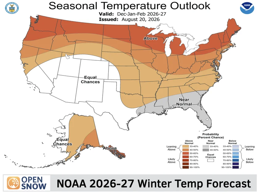
For winter, this typically means a more amplified and split jet stream. For the U.S. and Canada, this can translate into a persistent ridge of high pressure over western North America, leading to warmer and drier conditions in some areas, while a trough digs deeper into the eastern half of the continent, opening the door for Arctic air masses and repeated snowstorms. The situation is further complicated by early signals of a weakening Polar Vortex, which could allow frigid air to spill further south than usual.
The Old Farmer’s Almanac has also released its outlook for the 2026/27 winter, and while it suggests a generally mild and near-normal season for much of the U.S., it points out regional exceptions. The forecast called for a sharp divide: the West and parts of the South are expected to be wetter and potentially cooler, while the East and the Plains may see below-average precipitation. Snowfall is expected to be above normal in the Northeast, the Appalachian region, and parts of Alaska, a pattern that aligns with the expected El Niño influence.
How This Winter Could Unfold Across the U.S. and Canada
The month-to-month evolution of the winter will be critical. Early season forecasts suggest that the Super El Niño signal may strengthen further through late autumn, potentially reaching its peak during the winter months. This could lead to a scenario where the East Coast sees a significant amount of storm activity, with the potential for nor’easters and heavy snowfall similar to the winter of 2025/26, which featured Storm Hernando. The West, on the other hand, could experience a wetter-than-average winter, which is good news for drought relief but also carries a risk of flooding and heavy mountain snow. In Canada, the pattern may bring a mix of colder temperatures to the east, while the west remains relatively mild.
The economic and logistical stakes are high. Transportation networks, energy grids, and local communities will need to prepare for the possibility of extreme events. The agricultural sector in the U.S. also watches these long-range forecasts closely, as unexpected frosts or heavy rains can significantly impact winter crops and spring planting plans.
Perspective: A Season of Extremes and Uncertainty
The convergence of a Super El Niño with a weakening polar vortex creates a high degree of complexity and uncertainty. While long-range forecasts like those from the Old Farmer’s Almanac provide valuable guidance, meteorologists caution that these early predictions come with limitations. The exact timing and location of major winter storms are often impossible to forecast with precision months in advance. However, the underlying physical drivers are solid. The record ocean heat and the established El Niño signal provide a strong foundation for a winter that is anything but normal.
This winter is also being watched as a potential marker for a broader trend. With global temperatures continuing to rise, the interaction between natural climate cycles like El Niño and a warming atmosphere is becoming more complex. A Super El Niño may not only bring extreme cold to some regions but also exacerbate periods of drought or heavy rain in others. The presence of this powerful weather system is a reminder that winter is not simply a season of cold and snow, but a complex interplay of global forces that can have both immediate and long-term impacts on our environment, economy, and communities.
While the exact path of the upcoming storms is yet to be determined, the signal is clear: winter 2026/2027 will be defined by a major weather divide. As we saw with the Dust Storm Warning Hits Phoenix Area as Severe Storms Sweep Arizona, even expected weather patterns can produce unexpected intensity. For those in the northern hemisphere, preparing for a volatile winter season may be the wisest course of action.
Comments