Tornado Watches and Warnings Fill the Midwest as a Dangerous Week of Storms Unfolds
A relentless stretch of severe weather is hammering the central United States this week, forcing millions of residents across Kansas, Missouri, Wisconsin, and surrounding states to confront a question that becomes critically urgent every spring: what is the difference between a tornado watch and a tornado warning — and what exactly should you do when each one is issued?
On the evening of Monday, April 13, 2026, a tornado watch was in effect across the Kansas City metropolitan area before being canceled later that night as storms pushed eastward. The same day, at least one tornado was confirmed in Taylor County, Wisconsin, with another remaining unconfirced as of early Tuesday. A tornado siren in Wausau, Wisconsin, failed during its Monday testing — a troubling development as the week's threat continued to build. Damage survey teams were deployed across the Kansas City region by Tuesday morning as agencies worked to assess what the tornado-warned storms left behind.
The timing is not coincidental. This week marks Tornado and Severe Weather Awareness Week in Wisconsin, an annual initiative designed to educate the public about exactly these scenarios. With severe weather not just a drill but an active reality across much of the country, meteorologists from Green Bay to Kansas City are doubling down on one of the most important — and most misunderstood — distinctions in weather communication.
What Is a Tornado Watch — and What Should You Do?
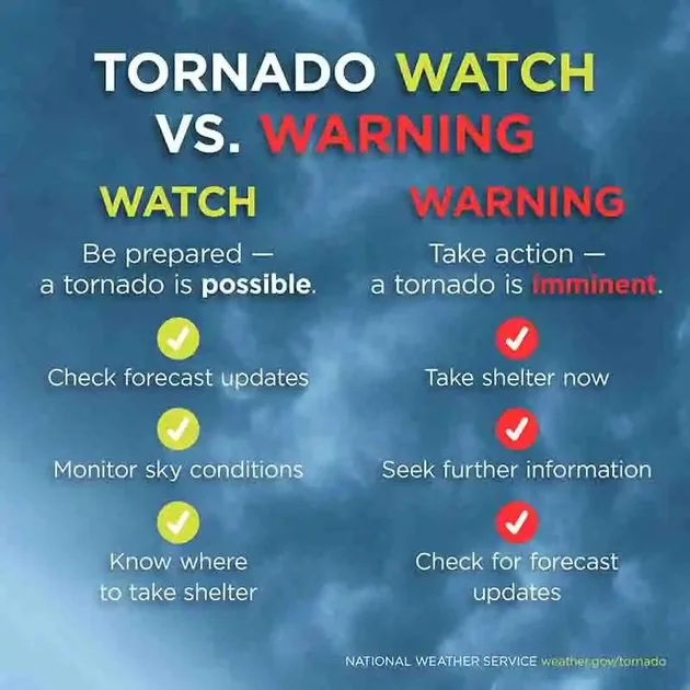
A tornado watch is issued by the Storm Prediction Center (SPC), a national forecasting office based in Norman, Oklahoma. It is a forward-looking alert, typically issued hours before any storm activity begins, and covers a large geographic area — often dozens of counties across multiple states.
The core message of a watch is preparedness, not panic. Conditions are favorable for tornado development, meaning the atmospheric ingredients — wind shear, instability, and moisture — are aligned in a way that makes tornadic thunderstorms possible. But no tornado has been confirmed, and severe weather may or may not materialize.
Scope and Duration of a Watch
A tornado watch is broad by design. It can span hundreds of miles and remain in effect for several hours. During the Monday night event in the Kansas City area, for example, the tornado watch covered a wide swath of the region before being canceled as the storm system matured and moved east.
What you should do during a watch:
- Stay alert and monitor local weather updates
- Have a plan in place and know your shelter location
- Keep a weather radio or smartphone app handy
- Do not wait for a warning to start preparing
The watch phase is your window to act before urgency becomes emergency.
What Is a Tornado Warning — and What Should You Do?
A tornado warning operates on an entirely different level of urgency. Unlike a watch, a warning is issued by local National Weather Service (NWS) offices — not a centralized national body. For most of north-central Wisconsin, for instance, warnings come from the NWS office in Green Bay, while other regions are covered by offices in cities like La Crosse, Duluth, Milwaukee, or Kansas City.
A tornado warning means one of two things: a tornado has either been physically spotted by a trained storm spotter, or radar has indicated strong rotational signatures consistent with a tornado. The threat is no longer theoretical — it is imminent or already occurring.
Scope and Duration of a Warning
Where a watch covers broad regions for extended periods, a warning is geographically tight and time-limited. It is typically issued for a specific set of counties or even parts of counties, and it may last only 30 to 60 minutes. This precision reflects the fast-moving, localized nature of tornadoes themselves.
What you should do during a warning:
- Go to your shelter immediately — do not wait
- Move to the lowest floor of a sturdy building
- Stay in an interior room, away from windows
- Get under a staircase or beneath a heavy piece of furniture if possible
- Do not attempt to outrun a tornado in a car
Meteorologsts emphasize that when a tornado warning is issued, the time for preparation is over. Action is required now.
Tornado Emergency: The Rarest and Most Severe Alert
Beyond the standard warning exists a third, less commonly known designation: the tornado emergency. This alert is reserved for situations where a violent tornado — typically a large, long-track EF4 or EF5 — is moving directly into a densely populated area. It represents the highest tier of tornado-related communication from the NWS and demands immediate, life-preserving action from everyone in the path.
Why This Week Is Especially Dangerous: A Multi-Day Severe Weather Pattern
This is not a one-day event. Forecasters across the Midwest are warning residents that the severe weather threat will persist through at least Friday, April 17.
In the Kansas City area, the Storm Prediction Center issued a Level 2 out of 5 severe risk for both Tuesday and Wednesday, with hazards including large hail, damaging straight-line winds, and the possibility of brief tornadoes. Meteorologists noted that while tornado risk remains lower on those days, it is not zero. Friday stands out as the most concerning day of the stretch: the SPC issued a medium risk (Level 3 out of 5) for severe weather — an unusual designation for a forecast made four days in advance, and one that forecasters explicitly flagged as a signal to pay close attention. The primary concerns for Friday include large hail, strong straight-line winds, and potentially large tornadoes.
Temperatures have contributed to the volatile setup. Kansas City recorded a low temperature of approximately 68 degrees early Tuesday — a figure that ties the record warmest low for that date, set in 2006. The unseasonable warmth is fueling the atmospheric instability that drives severe thunderstorm and tornado development.
For context on how warning systems are responding to increased storm activity nationwide, see our earlier reporting on Tornado Warning Alerts Surge Across the US: What's Happening and How to Stay Safe.
The Infrastructure Behind the Alerts: Who Issues What and Why
Understanding the institutional structure behind watch and warning issuances helps clarify why the system is designed the way it is.
The Storm Prediction Center in Norman, Oklahoma, operates as a national hub for mesoscale convective forecasting. Its scale and scope make it uniquely positioned to assess large-area threats hours in advance, which is why it issues watches rather than warnings. The SPC synthesizes atmospheric modeling, surface observations, and upper-air data to identify broad corridors of risk.
Local National Weather Service offices, by contrast, are embedded in their communities and have access to finely tuned local radar data. Their proximity — both geographic and operational — allows them to detect the rotation signatures and storm-spotter reports that justify issuing a warning for a specific neighborhood or county. This distributed architecture means that the system can scale from the national to the hyper-local in near-real time.
The Monday night failure of a tornado siren in Wausau during routine testing is a reminder that no single layer of this system should be relied upon exclusively. Weather professionals consistently advise that outdoor sirens are designed for people who are already outside — they are not intended as the primary warning mechanism for those indoors. Every home and business should maintain a NOAA weather radio with fresh batteries, and smartphone-based emergency alerts provide an additional layer of redundancy.
This point carries added weight given recent concerns about funding and staffing at federal meteorological agencies. The National Weather Service has faced scrutiny over budget pressures and staffing challenges — developments that make public understanding of these alert systems all the more critical.
What This Moment Reveals About Weather Communication and Public Preparedness
The convergence of an active severe weather outbreak with a dedicated awareness week underscores a broader tension in public safety communication: how do you keep people vigilant without desensitizing them to alerts?
Meteorologists are acutely aware of what researchers call "warning fatigue" — the tendency for repeated alerts to be tuned out, especially in regions that experience frequent but non-damaging severe weather. The watch-to-warning architecture is, in part, designed to counter this: by reserving the highest-urgency alert for confirmed or imminent threats, the system attempts to preserve the credibility and behavioral response that warnings depend on.
But the system only works if the public understands it. Surveys have repeatedly found that a significant portion of Americans conflate watches and warnings, or are unsure which requires immediate action. Severe Weather Awareness Week campaigns — like those running this week in Wisconsin — are a direct response to that gap.
This spring's outbreak also arrives against a backdrop of shifting severe weather patterns. Tornado activity has shown increasing variability in both geography and timing over recent years, with significant outbreaks occurring in months and regions historically considered lower-risk. That evolution makes the case for year-round weather literacy, not just seasonal campaigns.
For anyone in a watch or warning area this week — or in any future severe weather event — the core message from forecasters remains the same: a watch means get ready, a warning means act now. The distinction is not semantic. In the right circumstances, it is the difference between life and death.
Comments