Severe Thunderstorm Watch Expands Across US as World Cup Match Faces Weather Delays
A widespread severe thunderstorm watch has been issued for multiple regions across the United States on Monday, June 22, 2026, as a potent weather system brings damaging winds, heavy rainfall, and the risk of flash flooding. The National Weather Service (NWS) has placed portions of North Texas, the D.C.-Maryland-Virginia (DMV) area, New Jersey, and central Pennsylvania under alert, with some watches remaining in effect until 9 p.m. local time.
In North Texas, the watch covered a dozen counties, including Collin, Dallas, Denton, and Tarrant, ahead of the high-profile FIFA World Cup match between Argentina and Austria at Dallas Stadium. The watch, which expired at 11 a.m. Monday, prompted officials to advise fans to prepare for potential delays. Meteorologist Ali Turiano of FOX 4 noted that thunderstorms moving through the Metroplex could produce gusty winds and localized flooding, with heat index values climbing to 106 degrees later in the day.
Meanwhile, the DMV region faced a separate severe thunderstorm watch until 9 p.m., driven by fast-moving storms that already caused wind damage in Fairfax County, Virginia, and Page County. The 7News First Alert Weather Team reported that rainfall amounts of 1 to 2 inches could fall within 1 to 3 hours, raising concerns for flash flooding in low-lying areas. A brief tornado could not be ruled out as storms swept through the immediate metro area.
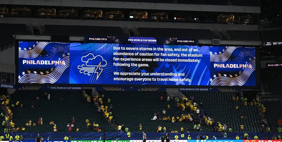
New Jersey and central Pennsylvania also fell under severe thunderstorm watches, with the NWS warning of damaging winds, hail, and locally heavy rainfall. The watch for 13 New Jersey counties—including Atlantic, Burlington, Camden, and Middlesex—coincided with the World Cup match at MetLife Stadium, which kicked off at 8 p.m. The weather service noted that storms could turn the game into a stormy mess, with rainfall rates hitting 1 to 2 inches per hour.
Why These Storms Matter: World Cup Disruptions and Flood Risks
The severe thunderstorm watch carries significant stakes for millions of residents and visitors, particularly those attending World Cup matches across North Texas and New Jersey. In Dallas, fans heading to Dallas Stadium to see Lionel Messi and the Argentine national team face Austria were urged to monitor conditions closely. The NWS advised that outdoor activities could face delays or cancellations if storms became severe. According to FOX 4, the active weather pattern will maintain heavy rain and flood risks across the Metroplex through Thursday, with morning lows in the mid-to-upper 70s and afternoon highs in the low-to-mid 90s.
In New Jersey, the stormy forecast cast a shadow over the World Cup game at MetLife Stadium. The NWS warned that multiple rounds of thunderstorms between 3 p.m. and 11 p.m. could disrupt the match, which is scheduled to start at 8 p.m. The flood watch remained in effect for 15 counties through 6 a.m. Tuesday, with the potential for flash flooding in areas with poor drainage. For fans traveling to the game, the storm risk added an extra layer of complexity, as power outages were already being reported across the state. NJ.com reported that a live power-outage tracker showed thousands without electricity due to the initial wave of storms.
The broader threat of flooding extends beyond match days. In North Texas, the NWS identified heavy rain and localized flooding as the primary concerns, with the highest rain chances expected north of Interstate 20. Pennsylvania officials echoed similar warnings, noting that rainfall could hit 2 to 3 inches per hour in the strongest storms, leading to rapid water rises on roads and in low-lying areas. The severe thunderstorm watch for central Pennsylvania counties—including Dauphin, Cumberland, and York—remained in effect until 9 p.m., with risks of damaging winds and tornadoes.
Broader Implications: Summer Storm Patterns and Public Safety
This wave of severe thunderstorm watches underscores a broader trend of active summer weather patterns across the United States, driven by high heat, humidity, and near-daily chances of rain and thunderstorms. The NWS has highlighted that such conditions are typical for late June in North Texas and the Northeast, but their intensity this year has raised concerns for public safety and event planning.
For World Cup fans, the weather disruptions serve as a reminder to have backup plans. The matches at Dallas Stadium and MetLife Stadium draw tens of thousands of spectators, many of whom may be unfamiliar with local weather risks. Lightning safety remains a critical issue: each year, lightning strikes the U.S. approximately 25 million times, mostly during summer, claiming about 20 lives annually, according to the NWS. Officials recommend that anyone outdoors during a thunderstorm seek shelter indoors, avoid corded phones and plumbing, and wait at least 30 minutes after the last thunderclap before resuming outdoor activities. More World Cup coverage can be found in our guide on BBC iPlayer World Cup 2026: How to Watch Every Game Live in UK and the match preview for Portugal vs Uzbekistan: Ronaldo’s Side Face Must-Win World Cup Group K Clash.
As the storms move eastward, conditions are expected to improve by Tuesday and Wednesday. In Pennsylvania, high pressure will build in, bringing mainly dry weather with temperatures in the 70s and low 80s. Similarly, a calmer pattern is anticipated across North Texas by the end of the week as high pressure takes hold, though the immediate focus remains on the ongoing severe weather risk.
For now, residents and visitors in affected areas should stay weather-aware, monitor local alerts, and prepare for potential power outages and travel disruptions. The storm system is likely to have lingering effects on commutes and outdoor events into Tuesday morning, especially in New Jersey and Pennsylvania.
Comments