
Tornado Warning Expires as Severe Storms Threaten New York City This Weekend
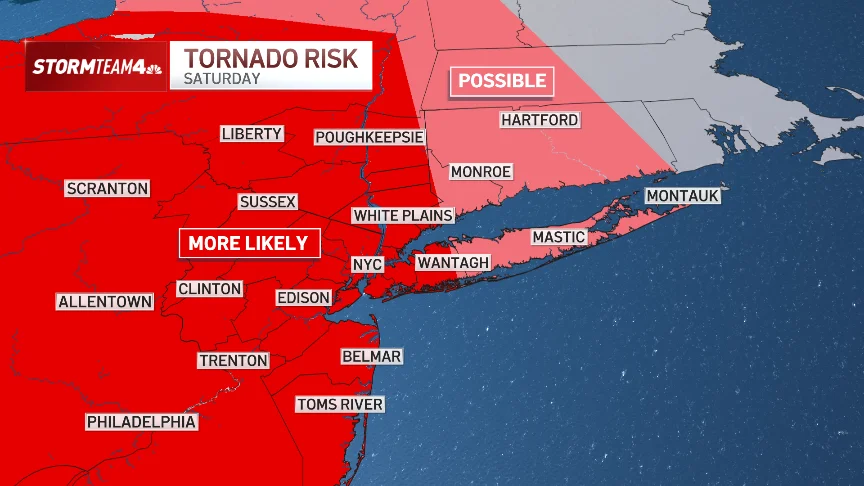
A tornado warning that covered parts of New Jersey expired Thursday evening, but the threat of severe weather—including possible tornadoes—remains high for New York City and the Tri-State Area this weekend. The National Weather Service has issued a flood watch from the morning of July 18 through 2 a.m. on July 19, as a series of fast-moving thunderstorms is expected to bring damaging winds, large hail, heavy rain, and the possibility of an isolated tornado.
The warning, which was in effect from just after 8 p.m. until 8:30 p.m. Thursday, covered south central Ocean County and southeastern Burlington County in New Jersey. While no tornado was confirmed, the alert underscores the volatile weather pattern gripping the region. According to amNewYork, the National Weather Service warned that some storms on July 18 could be severe, with damaging wind gusts as the primary threat and an isolated tornado possible.
New York City Emergency Management Department has officially issued a weather alert for the weekend. Mayor Zohran Mamdani urged residents to prepare: “Plan for travel delays and exercise caution while moving about the city. If the rain picks up, winds strengthen, or you hear thunder, go inside and wait out the dangerous conditions. Check on your neighbors, especially New Yorkers living in basement apartments, to be sure they’re taking the weather seriously.”
Commissioner Christina Farrell added that Saturday’s storms will be “fast-moving” but could produce “damaging winds and intense downpours with little warning.” With a full weekend of World Cup events and watch parties across the city, officials are asking New Yorkers to build flexibility into their plans and be ready to move indoors quickly.
Wildfire Smoke Blankets NYC: Air Quality Alert Extended
Before the storms arrived, New York City was shrouded in a thick layer of smoke and haze from wildfires burning in Ontario, Canada. More than 830 wildfires were burning across Canada, according to ABC News, along with more than a dozen in northern Minnesota, forcing mandatory evacuations and spreading unhealthy smoke into the United States.
On Wednesday, a cloudy orange haze blanketed the city’s iconic skyline. Air quality reached unhealthy levels in New York City and parts of the Eastern Lake Ontario region, Central New York, and Western New York. Mayor Mamdani urged New Yorkers to avoid unnecessary outdoor activities and stay inside in air-conditioned settings, offering free masks to help cope with the smoke.
The Air Quality Index peaked at 278 on Thursday night—though not as intense as the record 484 during the June 2023 smoke event, according to CBS New York. An Air Quality Alert was extended until Friday night at midnight for most of New Jersey. CBS New York’s forecast models indicate that smoke and haze will linger Friday, with the worst AQI levels in the city and points south. A brief drop in AQI levels is expected around 2 p.m. Friday for the city, before higher levels return by evening.
What’s at Stake: Flooding, Poor Air, and a Rare Severe Weather Pattern
This weekend’s weather is a convergence of several dangerous phenomena: extreme heat, dense wildfire smoke, and severe thunderstorms with tornado potential. The stakes are high for millions of residents in the Tri-State Area, many of whom are still recovering from a series of extreme weather events in recent years.
Flooding is a primary concern. Heavy rainfall expected on Saturday could lead to flash flooding, especially in urban areas with poor drainage. The flood watch covers all five boroughs, and NYC Emergency Management says it has cleared catch basins, staffed up emergency response teams, and placed its downed-tree task force on standby. Residents are encouraged to visit floodhelpny.org or the NYC Emergency Management website for flood zone information and resources.
Poor air quality adds another layer of risk. People with heart or lung conditions, older adults, pregnant New Yorkers, infants, and children are especially vulnerable. The combination of heat and smoke can exacerbate respiratory issues and lead to hospital visits. Saturday’s storms are expected to bring some relief, as heavy rain and wind will help disperse the smoke, but AQI levels may remain elevated earlier in the day.
A rare severe weather threat is also targeting northern New England and New York’s North Country, where NOAA’s Storm Prediction Center has issued a Level 3 out of 5 risk of severe thunderstorms. According to Fox Weather, these areas could see EF-2 tornadoes, damaging wind gusts up to 75 mph, and egg-sized hail. Storms are fueled by a heat dome baking much of the Northeast, with temperatures in the upper 90s to near-record highs. A powerful storm system moving out of Canada will collide with this hot, humid air, triggering thunderstorms.
Broader Implications: Climate Change and Urban Preparedness
The simultaneous threats of wildfire smoke and severe storms in a major metropolitan area like New York City highlight broader trends in climate-related disasters. Wildfires in Canada are becoming more frequent and intense, sending smoke hundreds of miles south more often. The June 2023 smoke event, when the AQI in NYC reached a record 484, was a wake-up call for many Americans. This week’s episode, though less extreme, shows that such events are no longer anomalies.
Severe storms with tornado potential are also becoming more common in regions not historically associated with twisters. While New York City rarely faces direct tornado threats, the region has seen an uptick in isolated tornadoes in recent years. In July 2024, an apparent tornado caused damage in Rome, New York, about 200 miles northwest of NYC. Experts say that as the climate warms, the atmosphere holds more energy, fueling stronger thunderstorms capable of producing tornadoes even in areas like the Northeast.
Urban centers face unique challenges during these dual emergencies. Dense populations, limited green space, and aging infrastructure can make flash flooding more dangerous. Wildfire smoke can linger in the concrete canyons of Manhattan. City officials are adapting by improving early warning systems, distributing masks, and coordinating with utility companies and transit authorities. Mayor Mamdani’s emphasis on checking on neighbors in basement apartments underscores the social vulnerability that extreme weather exposes.
On a broader scale, the convergence of heat, smoke, and storms could affect public health, travel, and major events. With World Cup watch parties scheduled across the city, organizers may need to adjust plans. Commuters should expect delays on subways and roads. The National Weather Service recommends staying indoors during thunderstorms and avoiding driving through flooded streets.
What Residents Should Do Now
New Yorkers and Tri-State residents are advised to take the following precautions:
- Sign up for emergency alerts by texting NOTIFYNYC to 692-692.
- Avoid outdoor activities when air quality is unhealthy. If you must go outside, wear an N95 mask or similar.
- During thunderstorms, move indoors immediately if you hear thunder. Stay away from windows and avoid using electrical appliances.
- If flooding occurs, move to higher ground. Never drive through floodwaters.
- Charge your phone and have emergency supplies ready, including flashlights and batteries.
- Check on elderly or vulnerable neighbors, especially those in basement apartments.
For real-time AQI updates, visit AirNow.gov. For flood resources, visit floodhelpny.org or the NYC Emergency Management website. Stay tuned to local news and weather alerts for the latest updates.
For a lighter read on community events, check out our coverage of Blue Ivy Steals the Show at Jay-Z's Yankee Stadium Concert with Piano Debut.
Looking Ahead: What’s Next?
The storm system is expected to move through the region Saturday, with improving conditions by Sunday. Smoke and haze levels should drop significantly after the storms pass, and air quality is expected to return to moderate levels by early next week.
However, the heat dome is not expected to break entirely. Temperatures will remain above average across the Northeast, and more rounds of thunderstorms are possible later next week. Residents should stay informed and remain prepared.
The events of the past week serve as a stark reminder that climate change is reshaping weather patterns, and that even major cities like New York are not immune to its effects. From record-breaking heat to wildfire smoke and tornado warnings, the Tri-State Area is experiencing a new normal—one that demands greater resilience and preparedness from both officials and residents.
Comments