
Hurricane Lowell Approaches Hawaii with Life-Threatening Surf and Heavy Rain
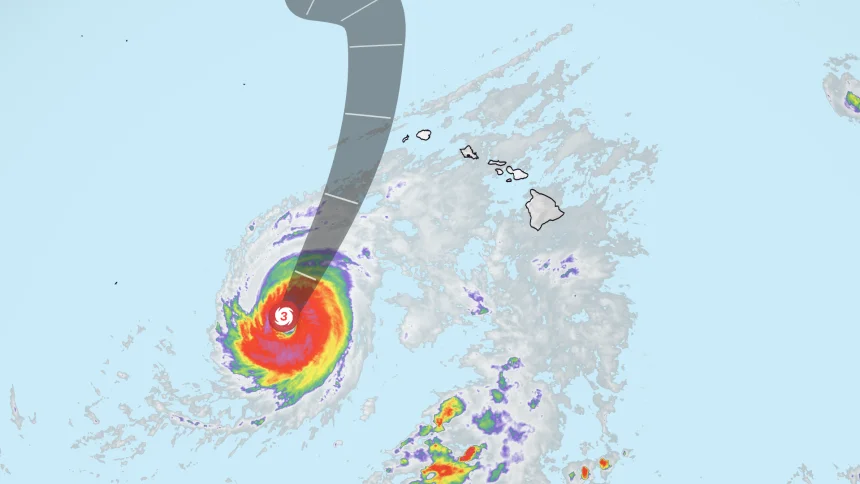
As of Sunday evening, Hurricane Lowell is churning about 500 miles south-southwest of Līhuʻe, Kauai, moving north at 9 mph. The storm, a powerful Category 3 with sustained winds of 120 mph, has prompted hurricane warnings for Kauai and Niʻihau, as well as for the Papahānaumokuākea Marine National Monument. Forecasters expect Lowell to pass just west of the main Hawaiian Islands Monday night, but even a near-miss could bring life-threatening surf, torrential rain, and damaging winds to the westernmost islands.
The National Hurricane Center (NHC) reports that Lowell's forecast cone places the center of the storm offshore, yet the margin for error is slim. "Just because we’re on the edge of the cone doesn’t mean we’re safe," warned John Bravender, warning coordination meteorologist at the National Weather Service. A slight eastward shift in the storm's track has increased the potential for tropical storm-force winds on Kauai and Niʻihau, according to Governor Josh Green. The state has already declared a state of emergency and activated the National Guard.
Forecast Timeline and Immediate Threats
Where Lowell is now: As of the 8 p.m. EDT advisory, the hurricane was centered approximately 500 miles south-southwest of Līhuʻe, moving north at 9 mph. Maximum sustained winds remain at 120 mph, making Lowell a high-end Category 3 storm. It has weakened from its peak Category 5 status reached on Wednesday, when winds exceeded 157 mph.
Forecast path: The NHC expects Lowell to continue moving north-northeast, picking up forward speed, and pass just west of Kauai and Niʻihau late Monday night into Tuesday morning. After that, it is forecast to turn north-northwest and slow down. While the storm will encounter cooler waters and increasing wind shear, it is still expected to maintain hurricane strength during its closest approach.
Impact timeline: Tropical storm conditions are expected in Kauai County within the next 36 hours. Heavy rainfall is forecast to begin Sunday afternoon, with flash flooding and landslides possible across the state. The most severe impacts—extremely dangerous surf, high winds, and flooding rain—are expected Monday through Tuesday.
Statewide Emergency and Preparations
Governor Josh Green declared a state of emergency on Friday, mobilizing the National Guard and urging residents to stay prepared. "We encourage everyone to remain prepared and continue following official weather updates," Green said in a statement. The declaration comes as Hawaii faces its third tropical threat in just over three weeks, following Hurricane Lala and Tropical Storm Moke, both of which caused significant damage in August.
Emergency management officials are particularly concerned about Kauai and Niʻihau, the westernmost islands in the chain. Niʻihau, with a population of just 84, is especially vulnerable due to its isolation and lack of infrastructure. Kauai, known for its lush mountains and steep terrain, faces the risk of mudslides and flash flooding from heavy rainfall.
The Hawaii Emergency Management Agency (HI-EMA) has issued flood watches for the entire state. A hurricane warning is in effect for Kauai and Niʻihau, while a tropical storm warning has been issued for the same areas, reflecting the potential for sustained winds of 39 mph or higher.
Rainfall and Surge Projections
Rainfall totals are expected to be substantial. The NHC forecasts 6 to 10 inches of rain on Kauai, with isolated amounts of up to 14 inches possible. The Big Island could see 4 to 8 inches, while Maui and other islands may receive 2 to 4 inches. Such rainfall on steep, saturated terrain could trigger life-threatening flash floods and landslides.
Storm surge is also a major concern. For Kauai County, a storm surge of 1 to 3 feet is possible, which could cause coastal flooding, especially during high tides. Oahu may see up to 1 foot of surge. Combined with waves expected to reach 30 feet on south- and west-facing shores, the potential for beach erosion and structural damage is high.
A Triple-Hurricane Event in the Pacific
Lowell is not alone in the Pacific. As of Saturday, three hurricanes were churning simultaneously: Lowell, Karina, and Marie. This marks the first time a decade that the central Pacific has seen three hurricanes at once. The NHC is also monitoring a fourth system off Mexico's coast, which could develop into a tropical storm.
The Pacific averages only eight hurricanes per year, making such simultaneous activity highly unusual. The storms are being fueled by unusually warm ocean waters, a trend scientists link to climate change. El Niño conditions are also expected to strengthen, potentially increasing storm activity in the region.
For Hawaii, this active season has already been taxing. Hurricane Lala caused at least $43 million in infrastructure damage on the Big Island, plus $4.6 million in home damage. Tropical Storm Moke brought heavy rainfall and strong winds just two weeks ago. Now Lowell threatens the western islands, which have been spared so far.
Historical Context and Local Preparedness
Hawaii rarely experiences direct hurricane landfalls, but it is vulnerable to near-misses that can still produce hurricane-force conditions. The state's geography—isolated, mountainous, and surrounded by ocean—makes it particularly susceptible to flooding and high surf. Residents in flood-prone areas are being urged to evacuate if ordered.
Emergency kits, sandbags, and shelter preparations are underway. Many residents on Kauai are boarding up windows and stocking supplies, mindful of the 1992 Hurricane Iniki, which devastated the island and killed six people. That storm made landfall as a Category 4, and Lowell's close approach has revived memories.
Broader Implications of an Active Hurricane Season
The 2026 hurricane season in the central Pacific has been remarkable not only for the number of storms but also for their intensity. Lowell reached Category 5 strength on Wednesday, making it only the second Category 5 hurricane of the season. Earlier, Hurricane Marie also intensified rapidly, bringing dangerous surf to California’s coast—a reminder that storms far offshore can have far-reaching impacts.
Climate scientists point to rising sea surface temperatures as a key driver of more intense hurricanes. Warmer waters fuel stronger storms, and the Pacific has been experiencing record-high temperatures. NOAA’s forecast for the 2026 season called for above-normal activity, and so far, the season is delivering.
Governor Green has emphasized the need for long-term resilience. "The climate crisis is here, and it demands we build a state that can withstand these storms," he said. But immediate priorities remain: keeping residents safe and minimizing damage. The state has increased emergency management funding and public messaging, but resources are stretched thin as multiple storms demand attention.
Lessons from Past Storms
Hurricane Sandy (2012) and Hurricane Harvey (2017) demonstrated how devastating flooding can be from storms that do not make direct landfall. In Hawaii, the fear is that Lowell could mimic a Kona low—a deep cyclone that can produce heavy rain on the southern and western sides of the islands, even if the center remains offshore. This is why forecasters stress the 'cone of uncertainty' doesn't guarantee a miss.
The situation highlights the importance of advanced warning systems and community preparedness. Hawaii's emergency response teams are being tested like never before, with activations for three storms in rapid succession. Each event strains resources, but also offers lessons in coordination and communication.
What This Means for Residents and Travelers
For those in Hawaii, especially on Kauai and Niʻihau, the next 48 hours are critical. Here are the key steps to take:
- Storm surge and surf: Avoid all coastal areas. Waves of up to 30 feet can easily sweep people off rocks and jetties.
- Flooding: Move to higher ground if you live in a flood-prone area. Flash floods are a real possibility, especially in valleys.
- Wind: Secure outdoor objects, and be prepared for power outages. Tropical storm-force winds can topple trees and power lines.
- Rain: Have a supply of food, water, and medication for at least three days. Landslides can cut off roads.
Visitors to the islands are urged to heed local advice and postpone any non-essential beach activities. Airlines have begun waiving change fees for flights to affected areas, and hotels are offering guidance.
Looking Ahead
Lowell is expected to weaken as it moves north, but it will remain a powerful hurricane as it passes Hawaii. After Monday, it is forecast to turn north-northwest and slow down, likely dissipating over cooler waters. However, the storm's legacy may be yet another test of Hawaii's resilience in a season that is already exhausting.
As meteorologist Bryan Norcross of FOX Weather noted, a direct hit on Kauai is unlikely but not impossible. What is certain is that life-threatening conditions will exist. The irony is that these storms are becoming more common as the climate warms, turning Hawaii into a frontline state for extreme weather.
For now, the focus is on the next 24 hours. As the hurricane approaches, the entire state holds its breath, hoping that the forecasts hold and the islands are spared the worst. But as Governor Green said, "We must be ready for the possibility that the storm could shift."
Comments