
Nor'easter Takes Shape Off East Coast, Threatening Millions
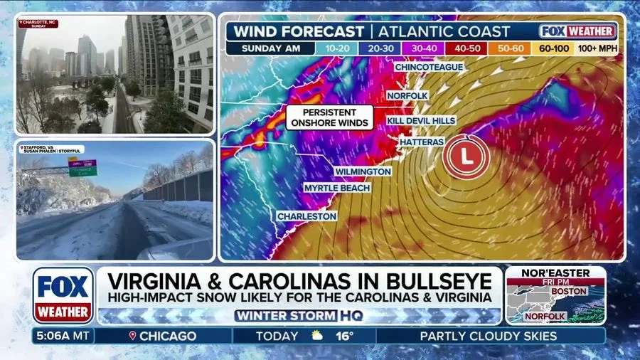
An early-season nor'easter is developing off the East Coast and is expected to bring a dangerous mix of strong winds, heavy rain, coastal flooding, and severe beach erosion from North Carolina's Outer Banks to New England, according to forecasts from weather.com and Fox Weather. The storm, still organizing as of September 23, 2026, could disrupt travel and weekend plans across the Northeast, including Boston and New York, where forecast models are beginning to converge on a solution.
"A nor'easter could form off the East Coast late this week, which could not only disrupt travel across the Northeast, but bring a threat of high surf, wind, rain and coastal erosion to the region," weather.com reported. The storm is being driven by an area of high pressure near the Great Lakes and a low-pressure system moving north along the coast; the tightening pressure gradient between the two will strengthen winds.
Outer Banks Face First Major Blow
The Outer Banks are already bracing for the first nor'easter of the season, with moderate coastal flooding expected to begin as early as Wednesday. Wind gusts of 40 to 50 mph are forecast to fuel offshore waves of 15 to 18 feet, according to Fox Weather. The National Weather Service warns of minor to locally moderate coastal flooding, large waves, dangerous surf, and beach erosion, with ocean overwash possible at vulnerable locations. N.C. Highway 12, a critical artery through Cape Hatteras National Seashore, is particularly vulnerable to overwash during prolonged periods of strong northeast winds.
"Pounding wave action across multiple high-tide cycles will trigger major coastal flooding and severe beach erosion," Fox Weather reported, noting that numerous homes along the Outer Banks have been destroyed by coastal flooding in recent years.
Mid-Atlantic and Northeast on Alert
Coastal flood alerts are already in place across the mid-Atlantic, where winds could push 1 to 3 feet of inundation above normal levels. The lower Chesapeake Bay region, including Norfolk, is expected to see increasing flood threats by late Wednesday. Widespread to extensive flooding is possible along the Bay.
Further north, forecast models show the storm could linger off the coast, bringing several inches of rain and gusty winds up to 45 mph that could cause power outages and travel delays. The European model suggests a slower, stronger storm that could meander near the East Coast until it fizzles, prolonging impacts. The GFS model shows a faster storm approaching New England by Saturday afternoon, which could reduce the severity of winds and rain but still deliver longer-lasting coastal impacts as it pulls away.
Uncertainty Remains, But Impacts Likely
While the exact track and timing of the nor'easter remain uncertain, forecasters agree that the storm will bring significant disruptions. "The models will continue to change as we get closer, so make sure to check back often as the forecast becomes clearer," weather.com advised. Regardless of the eventual path, several inches of rain are possible, raising concerns about flash flooding and hazardous travel.
A Region Already on Edge
The storm arrives as coastal communities continue to recover from recent seasons of destructive nor'easters and hurricanes. The Outer Banks, in particular, have seen repeated rounds of beach erosion and home collapses, leaving little buffer against new impacts. The early timing of this nor'easter—just days into astronomical fall—is also notable, as such storms typically become more common later in the season.
Broader Implications: A Test of Preparedness
The nor'easter serves as an early test of preparedness for coastal communities and emergency managers. With climate change contributing to rising sea levels and more intense precipitation events, the baseline risk for coastal flooding has increased. Even a moderate nor'easter can now cause more damage than in decades past.
For travelers and residents, the message is clear: monitor forecasts closely, prepare for possible power outages, and avoid coastal areas during high tide. As the storm evolves, officials from North Carolina to Maine will be watching the models and readying resources. This nor'easter may be the first of the season, but it is a reminder that the Atlantic hurricane and nor'easter seasons can bring dangerous conditions well into the fall.
Comments