
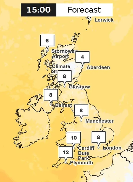
Met Office Warns of Colder Conditions and Wintry Showers
The Met Office has forecast a significant cold snap for the UK, with temperatures expected to plummet below freezing in many areas next week. According to the national weather agency, "colder conditions" are on the cards towards the end of next week, with "wintry showers" possible in some regions. Forecast models suggest daytime temperatures could drop below 0C for three consecutive days in 24 counties across Scotland, Wales, and northern England.
GFS weather model readings indicate that temperatures will start to fall from November 11, initially in Scotland before the freeze spreads to England and Wales. The mercury could plunge as low as -3C in northern Scotland around 6pm on November 11. Minimum temperature maps for November 12 show lows of -1C in southern Scotland and Wales, while the North Pennines in northern England could see -2C. Even southern areas like London are expected to see highs of just 4C, with East Anglia being the warmest at 6C.
The cold spell is expected to persist through November 13, with the North Pennines again the coolest at -1C, and temperatures in London as low as 4C at 6pm, with 2-3C in the Midlands and South Wales. Temperature anomaly maps show the UK shaded in deep blue, indicating temperatures well below the seasonal average.
Counties Facing Freezing Temperatures
The GFS model suggests 24 counties will see daytime temperatures drop below freezing across the three days. These include Cumbria, Northumberland, Lancashire, and Herefordshire in England; Ross-shire and Cromartyshire, Inverness-shire, Banffshire, Argyllshire, Perthshire, Aberdeenshire, Stirlingshire, Dunbarton, Lanarkshire, West Lothian, Midlothian, Ayrshire, Dumfriesshire, Peeblesshire, Selkirkshire, and Roxburghshire in Scotland; and Denbighshire, Merioneth, Montgomeryshire, and Radnorshire in Wales.
Polar Vortex Weakens, Raising Snow Chances
The cold snap comes as scientists report an unprecedented weakening of the polar vortex high above the Arctic. This circulation, which typically traps the coldest air near the pole, has weakened and shifted position in recent days. According to the BBC, scientists say an event this early in November is unprecedented in modern observations.
Jeff Knight, lead climate scientist from the Met Office, told the BBC: "It would appear to be the earliest on record looking back over the 75 years we've been observing…with most experts agreeing this is a very unusual event." The current earliest major sudden stratospheric warming (SSW) event occurred on November 28 in 1969 and 2025.
Similar disruptions in past years have sometimes been followed by colder weather affecting parts of Europe and North America. As the vortex weakens, changes in the stratosphere can alter the position of the jet stream, increasing the chance of a blocked weather pattern where it can become drier with a colder northerly or easterly wind bringing Arctic air in. This can boost the possibility of snow, especially in eastern UK.
However, as this is happening so early in the season, there are few historical examples to compare with, and it could throw current winter forecasts into even more uncertainty. The reasons for such an early event are not clear; it could be part of the natural variability of weather patterns, or linked to El Niño conditions.
Wintry Showers and Snow Forecast
Separately, the Met Office's long-range forecast covering November 11 to December 5 suggests that outbreaks of rain across the south will clear as clearer conditions spread from the north. While snow is largely not being forecasted at this time, the agency added that a "few wintry showers are likely in the far north, but otherwise this will mean a spell of fine and dry weather developing for most areas."
The Met Office confirmed that "wintry shower" is generally used to describe rain that could include a component of sleet, snow, and possibly hail. It can also be used in a general context where across a broad area there could be separate patches of snow and sleet.
Looking further ahead, the forecaster says "a change to more changeable weather is likely" over the following weekend, with Atlantic frontal systems bringing rain and some strong winds. Unsettled or changeable weather will likely continue through the following week. After a cold start, temperatures will probably be above average overall.
From November 21 to December 5, the Met Office expects changeable or unsettled conditions through the last part of November. Atlantic frontal systems are likely to spread across the UK, bringing some heavy rain at times and a chance of strong winds. Drier, brighter interludes are likely between systems, and it is possible conditions could become drier overall into early December. Temperatures are likely to be above normal overall.
Snow Maps Show Potential for Significant Snowfall
Meanwhile, weather maps from WXCharts show snowfall covering much of Scotland on Sunday, November 15. A 131-mile-long snow bomb is forecast to stretch from Stirling up as far as Ullapool. Temperatures in the region could reach as low as -1C in Scotland, and as low as 3C or 4C in England and 1C in Wales.
However, it's worth noting that snow forecasts can change suddenly, as conditions have to be exact for it to snow. Any slight change in temperature or air moisture levels could mean it will or will not snow.
The Met Office's forecast for next week is uncertain but predicts a shift in weather patterns. "High pressure begins to migrate away to the east, allowing frontal systems to progress into the UK from the southwest, although exactly how much progress into the UK this makes is uncertain," it says. "However, there is a greater chance that at least the southern half of the UK will see a change to milder and wetter conditions, at least for a time, while the north is more likely to remain drier."
What This Means for the UK
The impending cold snap marks a sharp change from the milder conditions many have experienced recently. After a record-breaking summer of heatwaves, the colder weather may feel like a relief to some, but it also signals a true start to winter. Households have already been turning on their heating to stay warm.
The unusual early weakening of the polar vortex adds a layer of uncertainty to winter forecasts. While it raises the possibility of snow, especially in eastern areas, the exact impacts remain unclear. The Met Office and other forecasters will continue to monitor the situation closely.
As ever, weather forecasts can change, and residents are advised to stay updated with the latest information. For those in affected areas, it may be wise to prepare for colder conditions and possible travel disruptions. The cold spell is expected to be relatively short-lived, with milder and wetter conditions likely to return towards the end of the month.
In the meantime, the UK braces for a taste of winter, with the Met Office's warnings serving as a reminder that despite the early date, the season's chill is already making itself felt.
Comments