
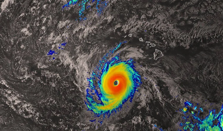
Hurricane Nolo Intensifies to Category 4, Skirts Hawaii
Hurricane Nolo rapidly intensified into a Category 4 storm on Sunday, September 27, 2026, as it churned westward, passing well south of the Hawaiian Islands. As of 5 p.m. local time, Nolo boasted maximum sustained winds of 145 mph and was located approximately 380 miles south-southwest of Honolulu, moving west-northwest at 12 mph, according to the Central Pacific Hurricane Center (CPHC). While the storm's center remained far from the main islands, its expansive wind field and powerful surf continued to batter portions of the state, prompting a slew of advisories and warnings.
Current Threats: High Surf, Wind Advisories, and Rain
Despite the distance, Nolo's effects were palpable across the archipelago. A high surf advisory remained in effect for east-facing shores of Oahu and Kauai until 6 a.m. Monday, with large breaking waves of 8 to 12 feet expected. A wind advisory for portions of Maui, Molokai, Oahu, and Hawaii Island was also in place until 6 a.m. Monday, with forecasters anticipating east winds of 20 to 30 mph and gusts up to 50 mph. Additionally, a small craft advisory covered numerous coastal waters, including Kauai Northwest Waters, Oahu Windward Waters, and the Kaiwi Channel, among others, until 6 p.m. Monday.
By Monday, September 28, Nolo had weakened slightly to a Category 3 hurricane with maximum sustained winds of 125 mph, but it continued to pose a threat, particularly to the Papahānaumokuākea Marine National Monument. A hurricane warning remained in effect for the monument from Nihoa to French Frigate Shoals. As of 5 p.m. Monday, Nolo was located about 390 miles south-southeast of French Frigate Shoals and 415 miles west-southwest of Honolulu, moving northwest at 13 mph. The storm was forecast to turn north on Tuesday and approach the monument, bringing dangerous conditions.
Meanwhile, Kauai County braced for increased rainfall starting Tuesday, as Nolo's outer bands were expected to sweep over the island. The National Weather Service warned that the storm's slow movement could lead to prolonged periods of rain, raising concerns about flash flooding and mudslides, especially in areas already saturated from previous storms.
Context: A State Still Recovering from Hurricane Lala
Nolo's passage comes less than a month after Hurricane Lala, a powerful storm that devastated parts of the Big Island, sweeping about 100 homes off their foundations and causing widespread flooding. The recovery effort is ongoing, and the new threat of heavy rain has officials on edge. "We can have trees and power lines down," warned Michael Brennan, director of the National Hurricane Center. "Don't venture out if you don't have to into the dangerous flooding environment, but also high winds."
On Saturday, heavy rain from Nolo's outer bands already caused flooding on the Big Island, prompting partial closures of the Mamalahoa Highway, a key route linking Kailua-Kona and Hilo. Hawaii County Civil Defense Agency reported that more than 120 National Guard members were activated on the island, part of roughly 400 statewide after Governor Josh Green issued an emergency proclamation. Residents in low-lying areas were urged to evacuate, and emergency shelters were opened.
The storm also disrupted travel, with Southwest Airlines and other carriers canceling flights to Hilo International Airport, where sandbags lined ticket counters as a precaution. Meanwhile, a new phenomenon known as "volcanic hail" or tephra—fragments of volcanic rock and ash—was detected at Kilauea volcano, adding to the complex hazards. Hawaii County Mayor Kimo Alameda told ABC News that precursor activity at the volcano could spew tephra into the air, potentially impacting downwind communities.
Forecast: Nolo's Complex Path and Uncertain Future
As Nolo continues its slow trek, forecasters are closely monitoring its interaction with an upper-level low approaching from the northwest. According to the CPHC, "The track forecast becomes more complex by midweek, as the strength and track of this low will play a significant role in determining Nolo's subsequent motion." The hurricane is expected to turn north on Tuesday, but its exact path remains uncertain. Some models suggest it could stall or loop, prolonging the threat to the monument and possibly bringing more rain to the main islands.
Nolo is forecast to weaken over the next couple of days as it encounters cooler waters and wind shear, but it may re-strengthen later in the week as it moves over warmer waters. "Nolo will weaken over the next couple of days then gain strength again during the latter part of this week," forecasters said. This potential rebound underscores the need for continued vigilance.
Broader Implications: A Hyperactive Pacific Hurricane Season
Nolo is one of three active hurricanes in the Pacific, alongside Hurricane Polo and Hurricane Odalys. Polo, a major Category 3 storm with winds of 120 mph, is forecast to impact Mexico's Baja California Sur with tropical storm conditions early this week, while Odalys, a Category 1 hurricane, is expected to weaken and dissipate south of Hawaii. The simultaneous occurrence of three hurricanes in the Pacific is rare; the last time this happened was in 2015 with Kilo, Ignacio, and Jimena.
This clustering of storms aligns with broader climate trends. Warmer sea surface temperatures, fueled by climate change, are providing more energy for tropical cyclones to intensify rapidly. Nolo's jump from a Category 2 to Category 4 in just 24 hours is a prime example of rapid intensification, a phenomenon that scientists say is becoming more common. The Central Pacific is also experiencing a La Niña pattern, which can shift storm tracks and increase the likelihood of hurricanes near Hawaii.
For Hawaii, the increasing frequency of close calls and direct hits is a sobering reality. Hurricane Lala was a wake-up call, and Nolo serves as another reminder that the islands are vulnerable. Emergency management officials are urging residents to remain prepared, with hurricane kits and evacuation plans at the ready. As the 2026 season continues, the focus will be on resilience and adaptation in the face of a changing climate.
Conclusion: A Close Call with Far-Reaching Effects
While Hawaii has dodged a direct hit from Nolo, the storm's impacts are far from over. High surf, gusty winds, and heavy rain will continue to affect the islands, particularly Kauai and the Papahānaumokuākea monument. The complex forecast and potential for re-intensification mean that residents and authorities must stay alert. As the Pacific churns with multiple storms, Hawaii's experience with Nolo highlights the importance of preparedness and the growing challenges of a warming world.
For now, the Aloha State can breathe a sigh of relief that the worst has been avoided, but the lessons from this near-miss will linger. With recovery from Lala still underway, the resilience of Hawaii's communities will be tested once again. As officials continue to monitor Nolo's every move, the message is clear: stay informed, stay safe, and stay prepared.
Comments